Nangloi Metro Station, situated in West Delhi, is an elevated station on the Delhi Metro's Green Line (Line 5). It was inaugurated on 2 April 2010 as part of the initial 15.1 km stretch between Inderlok and Mundka. The station serves as a vital transit point, connecting residential and commercial areas such as Nangloi, Paschim Vihar, and Mundka. It facilitates seamless travel between Inderlok and Brigadier Hoshiyar Singh stations, enhancing connectivity in the region.
Nangloi Metro Station - Quick Info
This quick guide covers station specifics like Nangloi metro timings, Nangloi metro line, metro station parking, and nearby facilities. Get all the details you need for a smooth commute from this West Delhi station.
| Station Information | Details |
| Metro Station Location | Rohtak Road, Opposite Surajmal Stadium, Nangloi, Delhi |
| Other Name | Nangloi Station |
| Owner | Delhi Metro Rail Corporation Ltd. (DMRC) |
| Operational Date | 2nd April 2010 |
| Line | Green Line (Line 5) |
| Type | Elevated |
| Number of Platforms | 2 (Side platforms) |
| First Metro (Approx.) | 06:00 AM |
| Last Metro (Approx.) | 11:00 PM |
| Fare Range | ₹10 – ₹60 (approx., varies by distance) |
| Nearby Stations | Nangloi Railway Station (adjacent), Maharaja Surajmal Stadium |
| First and Last Stops | Inderlok / Kirti Nagar – Brigadier Hoshiyar Singh (Bahadurgarh) |
| Station Parking | Available (Paid parking for two-wheelers & cars) |
| Address Map | Q-Block, Nangloi Jat, New Delhi, Delhi 110041 (Map Link) |
| Review/Rating (Approx.) | 3.9/5 (Based on user feedback) |
Nangloi Metro Station Map
The Nangloi Metro Station is an essential part of the Delhi Metro. It is on the Green Line, which connects Inderlok/Kirti Nagar with Brigadier Hoshiyar Singh (Bahadurgarh). It is located on the busy Rohtak Road (NH9) near Nangloi Railway Station and Maharaja Surajmal Stadium. Use the map below to understand the Nangloi Metro Station route map, check nearby landmarks, and plan your travel across Delhi and into Haryana using the Nangloi Metro.
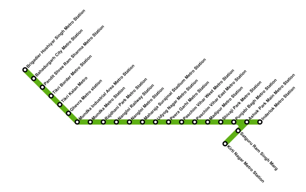 Nangloi Metro Station route map
Nangloi Metro Station Platform Details
Nangloi Metro Station features two elevated side platforms serving the Green Line. Platform 1 is designated for trains travelling westbound towards Brigadier Hoshiyar Singh (Bahadurgarh), connecting areas like Mundka and Ghevra and extending into Haryana. Platform 2 serves eastbound trains heading towards Inderlok and Kirti Nagar, linking Central and North Delhi. The station offers basic amenities like ticketing, seating, and accessibility features.
From Nangloi Metro Station, Platform 1 trains proceed towards Brigadier Hoshiyar Singh on the Green Line extension. This Nangloi metro route primarily serves industrial and developing residential areas in West Delhi and Bahadurgarh.
- Nangloi
- Rajdhani Park
- Mundka
- Mundka Industrial Area (MIA)
- Ghevra
- Tikri Kalan
- Tikri Border
- Pandit Shree Ram Sharma (Modern Industrial Estate)
- Bahadurgarh City
- Brigadier Hoshiyar Singh (Bahadurgarh)
Platform 2 at Nangloi Metro Station facilitates travel towards the core Delhi network via Inderlok and Kirti Nagar interchanges. This popular Nangloi metro route connects to key residential and commercial areas of West Delhi.
- Nangloi
- Maharaja Surajmal Stadium
- Udyog Nagar
- Peeragarhi
- Paschim Vihar West
- Paschim Vihar East
- Madipur
- Shivaji Park
- Punjabi Bagh West (Interchange walk with Pink Line)
- Punjabi Bagh East
- Ashok Park Main (Trains bifurcate here)
- Towards Inderlok: Satguru Ram Singh Marg -> Inderlok (Interchange with Red Line)
- Towards Kirti Nagar: Moti Nagar -> Kirti Nagar (Interchange with Blue Line)
Nangloi metro station to Nangloi distance
Nangloi Metro Station distance from Nagloi is a few hundred meters to 1-2 km as it is situated within Nangloi itself, specifically on the main Rohtak Road (NH9), adjacent to the Nangloi Railway Station flyover and near Nangloi Chowk.
Nangloi Metro Station Timings Details
Nangloi Metro Station timings align with the standard DMRC schedule. The Nangloi Metro provides frequent trains, especially during peak commuting hours, serving the busy Green Line corridor. Always check the official DMRC sources for the most accurate first and last train timings for your journey.
Operating Hours (Approximate):
- Monday to Saturday: 06:00 AM to 11:00 PM
- Sunday and Public Holidays: Timings might vary slightly (confirm with DMRC).
- Peak Hour Frequency: Every 4-6 minutes
- Off-Peak Hour Frequency: Every 7-12 minutes
Nangloi Metro Station Ticket Fares
The DMRC's distance-based fare system determines ticket fares from Nangloi Metro Station. Commuters can purchase single-journey tokens or use Delhi Metro Smart Cards for cost savings and convenience. Smart card users benefit from a 10% discount on each journey, with an additional 10% discount during designated off-peak hours.
Nangloi Metro Station Entry & Exit Points
Nangloi Metro Station typically provides multiple entry and exit gates to manage passenger flow effectively from Rohtak Road.
- Gate 1: Often opens towards Nangloi Railway Station side / Nangloi Chowk.
- Gate 2: It usually opens towards the opposite side of Rohtak Road / Surajmal Stadium.
Nangloi Metro Station Parking Details
Nangloi Metro Station Parking is a paid facility for commuters. Managed by DMRC-authorised contractors, the parking lot accommodates two—and four-wheelers. Parking charges are typically levied hourly or daily.
Best Areas to Live Near Nangloi Metro Station
Living near Nangloi Metro Station offers affordable housing options and direct Green Line connectivity. The surrounding areas are densely populated and primarily cater to budget and mid-segment residents. Here are some areas to consider:
1. Nangloi Extension & Nangloi Jat
- Distance from station: 0-2 km
- Property types: Independent houses, flats, and small apartments in dense layouts.
- Key features: It is very close to the metro, highly affordable, has extensive local markets, and an adjacent railway station. However, it can be congested.
- Average Rent (Approx.): 1 RK/1 BHK ₹4k-8k; 2 BHK ₹7k-12k.
Properties for Rent in Nangloi Extension
2. Rajdhani Park
- Distance from station: 1-2 km (Next metro stop)
- Property types: Mostly independent floors and houses.
- Key features: Developing residential area, slightly less congested than core Nangloi, affordable.
- Average Rent (Approx.): 1 BHK ₹5k-9k; 2 BHK ₹8k-15k.
3. Sultanpuri
- Distance from station: 3-4 km
- Property types: Resettlement colony with independent houses and floors.
- Key features: Very affordable, large residential area, well-connected by road.
- Average Rent (Approx.): 1 RK/1 BHK ₹3k-7k; 2 BHK ₹6k-10k.
Properties for Rent in Sultanpuri
4. Paschim Vihar (Outer areas)
- Distance from station: 4-5 km (Requires travel towards Peeragarhi)
- Property types: DDA flats, builder floors, independent houses.
- Key features: It is a more planned locality than Nangloi, with better amenities, numerous parks, and markets. The rent segment is higher.
- Average Rent (Approx.): 1 BHK ₹10k-18k; 2 BHK ₹15k-25k; 3 BHK ₹22k-35k+.
Properties for Rent in Paschim Vihar
5. Mundka
- Distance from station: 3-4 km (Towards Bahadurgarh)
- Property types: Mix of village areas, plotted developments, and industrial zones. Some affordable residential options.
- Key features: Proximity to Mundka Industrial Area, very affordable land/rent, and the next few stops on the Green Line.
- Average Rent (Approx.): Highly variable, generally low, similar to Nangloi/Rajdhani Park.
Properties for Rent in Mundka
The Latest Update On Nangloi Metro Station Route
Navigating from Nangloi Metro Station is easy with the Green Line's connectivity. Platform 1 trains head towards Brigadier Hoshiyar Singh (Bahadurgarh), while Platform 2 trains proceed towards Inderlok (connecting to the Red Line) and Kirti Nagar (linking to the Blue Line). Let's explore more about the various areas Nangloi Metro Station connects with:
Travelling from Nangloi Metro Station to Anand Vihar Metro Station
The journey from Nangloi Metro Station to Anand Vihar ISBT Metro Station requires one interchange at Kirti Nagar. Board from Platform 2 (towards Kirti Nagar), get off at Kirti Nagar, and switch to the Blue Line (Platform 1 towards Noida Electronic City/Vaishali) to reach Anand Vihar ISBT. This route connects West Delhi to East Delhi's major transit hub.
| Detail | Information |
| Time of First Metro | ~06:00 AM |
| Time of Last Metro | ~11:00 PM |
| Travelling Time | 50-55 minutes (approx.) |
| Total Distance | 28 km (approx.) |
| Number of Stops | 30 stations (approx.) |
| Interchange | 1 (Kirti Nagar - Green to Blue Line) |
| Fare of Token | ₹50 (approx.) |
| Fare of Smart Card | ₹45 (approx.) |
Nearby Markets and Places (Anand Vihar):
- Pacific Mall
- Anand Vihar ISBT & Railway Terminal
- Cross River Mall (nearby)
Best Areas to Live (Near Anand Vihar):
- Patparganj (Approx. 2-4 km)
- Kaushambi (Ghaziabad) (Approx. 1-2 km)
- IP Extension (Approx. 3-5 km)
Travelling from Nangloi Metro Station to New Delhi Metro Station
The distance to the New Delhi Metro Station from the Nangloi Metro Station requires two interchanges. Board from Platform 2 (towards Kirti Nagar), change at Kirti Nagar to the Blue Line (Platform 1 towards Noida/Vaishali), travel to Rajiv Chowk, and interchange again to the Yellow Line (Platform 1 towards Samaypur Badli) to reach New Delhi Station (one stop).
| Detail | Information |
| Time of First Metro | ~06:00 AM |
| Time of Last Metro | ~11:00 PM |
| Travelling Time | 45-50 minutes (approx.) |
| Total Distance | 19 km (approx.) |
| Number of Stops | 18 stations (approx.) |
| Interchange | 2 (Kirti Nagar - Green to Blue; Rajiv Chowk - Blue to Yellow Line) |
| Fare of Token | ₹40 (approx.) |
| Fare of Smart Card | ₹36 (approx.) |
Nearby Markets and Places (New Delhi):
- New Delhi Railway Station
- Paharganj Market
- Connaught Place (via Rajiv Chowk)
Best Areas to Live (Near New Delhi Station - Limited Residential):
- Paharganj (Budget Hotels/Guesthouses)
- Karol Bagh (via Blue Line, Approx. 3-4 km)
- Civil Lines (via Yellow Line, Approx. 4-6 km)
Travelling from Nangloi Metro Station to Nizamuddin Metro Station
The Nangloi to Nizamuddin metro route involves one interchange at Punjabi Bagh West. Board from Platform 2 (towards Inderlok/Kirti Nagar), alight at Punjabi Bagh West station (requires a short walk via foot overbridge between Green Line and Pink Line platforms), and take the Pink Line (Platform 2 towards Shiv Vihar) directly to Hazrat Nizamuddin.
| Detail | Information |
| Time of First Metro | 05:30 AM |
| Time of Last Metro | 11:21 PM |
| Travelling Time | 60-65 minutes (approx.) |
| Total Distance | 30 km (approx.) |
| Number of Stops | 28 stations (approx., including transfer) |
| Interchange | 1 (Punjabi Bagh West - Green to Pink Line) |
| Fare of Token | ₹50 (approx.) |
| Fare of Smart Card | ₹45 (approx.) |
Nearby Markets and Places (Nizamuddin):
- Hazrat Nizamuddin Railway Station
- Sarai Kale Khan ISBT
- Humayun's Tomb
- Nizamuddin Dargah
Best Areas to Live (Near Nizamuddin):
- Jangpura (Approx. 1-2 km)
- Lajpat Nagar (Approx. 2-3 km)
- Nizamuddin East/West
Travelling from Nangloi Metro Station to Chattarpur Metro Station
The Nangloi to Chattarpur metro route spans about 30 km and takes approximately 65-70 minutes with one interchange at Inderlok. Board the train from Platform 2 (towards Inderlok), get down at Inderlok, and switch to the Red Line (Platform 2 towards Rithala) for one stop to Kashmere Gate. Correction: The optimal route is Green -> Yellow at Inderlok. Board Platform 2 towards Inderlok, interchange to the Yellow Line (Platform 2 towards HUDA City Centre) and travel directly to Chattarpur.
| Detail | Information |
| Time of First Metro | ~05:30 AM |
| Time of Last Metro | ~11:00 PM |
| Travelling Time | 60-65 minutes (approx.) |
| Total Distance | 30 km (approx.) |
| Number of Stops | 25 stations (approx.) |
| Interchange | 1 (Inderlok - Green to Yellow Line) |
| Fare of Token | ₹50 (approx.) |
| Fare of Smart Card | ₹45 (approx.) |
Nearby Markets and Places (Chattarpur):
- Chattarpur Temple Complex
- Qutub Minar (nearby via auto)
- Mehrauli Archaeological Park
Best Areas to Live (Near Chattarpur):
- Chattarpur Extension (Farmhouses, apartments)
- Sultanpur (Approx. 1-2 km)
- Mehrauli (Approx. 2-3 km)
Travelling from Nangloi Metro Station to Kashmere Gate Metro Station
Travelling from Nangloi Metro Station to Kashmere Gate Metro Station requires one interchange at Inderlok. Board the train from Platform 2 (towards Inderlok), alight at Inderlok, and switch to the Red Line (Platform 2 towards Rithala Metro Station) for one stop to reach Kashmere Gate. Correction: Switch to Red Line (Platform 1 towards Shaheed Sthal). Kashmere Gate is a major interchange hub.
| Detail | Information |
| Time of First Metro | ~05:30 AM |
| Time of Last Metro | ~11:00 PM |
| Travelling Time | 30-35 minutes (approx.) |
| Total Distance | 16 km (approx.) |
| Number of Stops | 17 stations (approx.) |
| Interchange | 1 (Inderlok - Green to Red Line) |
| Fare of Token | ₹40 (approx.) |
| Fare of Smart Card | ₹36 (approx.) |
Nearby Markets and Places (Kashmere Gate):
- Kashmere Gate ISBT
- Ladakh Buddhist Vihara
- St. James' Church
- Old Delhi Railway Station (short ride)
Best Areas to Live (Near Kashmere Gate):
- Civil Lines (Approx. 1-2 km)
- Tis Hazari (Court complex area)
- Kamla Nagar (University area, approx. 3-4 km)
Travelling from Nangloi Metro Station to Rajiv Chowk Metro Station
The route from Nangloi Metro Station to Rajiv Chowk involves one interchange at Kirti Nagar. Board the train from Platform 2 (towards Kirti Nagar), get down at Kirti Nagar, and change to the Blue Line (Platform 1 towards Noida Electronic City/Vaishali) to reach Rajiv Chowk, the heart of Delhi's Connaught Place.
| Detail | Information |
| Time of First Metro | ~05:30 AM |
| Time of Last Metro | ~11:21 PM |
| Travelling Time | 30-35 minutes (approx.) |
| Total Distance | 18 km (approx.) |
| Number of Stops | 20 stations (approx.) |
| Interchange | 1 (Kirti Nagar - Green to Blue Line) |
| Fare of Token | ₹40 (approx.) |
| Fare of Smart Card | ₹36 (approx.) |
Nearby Markets and Places (Rajiv Chowk):
- Connaught Place (Inner, Middle, Outer Circles)
- Janpath Market
- Palika Bazaar
- Jantar Mantar
Best Areas to Live (Near Rajiv Chowk - Mostly Commercial):
- Connaught Place (Very expensive, limited residential)
- Barakhamba Road Area (Apartments, expensive)
- Mandi House Area (Cultural hub, some housing)
Travelling from Nangloi Metro Station to IFFCO Chowk Metro Station
Travelling from Nangloi Metro Station to IFFCO Chowk in Gurgaon requires two interchanges at Inderlok and Kashmere Gate. Board from Platform 2 (towards Inderlok), interchange at Inderlok to the Red Line (Towards Dilshad Garden Platform 2). Then get off at Kashere Gate, go towards Huda City Centre Platform 1 on the Yellow line, and travel to IFFCO Chowk in Gurgaon.
| Detail | Information |
| Time of First Metro | ~05:30 AM |
| Time of Last Metro | ~11:22 PM |
| Travelling Time | 75-80 minutes (approx.) |
| Total Distance | 43 km (approx.) |
| Number of Stops | 33 stations (approx.) |
| Interchange | 2(Inderlok - Green to Yellow Line) |
| Fare of Token | ₹60 (approx.) |
| Fare of Smart Card | ₹54 (approx.) |
Nearby Markets and Places (IFFCO Chowk):
- MGF Metropolitan Mall
- Sahara Mall
- Kingdom of Dreams (nearby)
- Cyber Hub (few stations away on Rapid Metro or short ride)
Best Areas to Live (Near IFFCO Chowk):
- Sector 29, Gurgaon (Entertainment hub, limited residential)
- Sushant Lok Phase 1 (Approx. 2-4 km)
- DLF Phase 4 (Approx. 2-3 km)
- Sector 17, Gurgaon (Approx. 1-2 km)
Why Invest Near Nangloi Metro Station?
Investing near Nangloi Metro Station could offer long-term potential, primarily driven by affordability and connectivity improvements.
- Convenience & Connectivity: The Green Line provides direct access to Bahadurgarh and crucial interchanges (Kirti Nagar for Blue, Inderlok for Red, Punjabi Bagh West for Pink), efficiently connecting West Delhi. Proximity to Rohtak Road (NH9) is also beneficial.
- Potential Property Value Boost: While already established, infrastructure improvements and the "metro effect" could lead to gradual property value appreciation, especially compared to more saturated parts of Delhi. It remains an affordable entry point into Delhi's real estate market.
- Target Audience Specific: The area primarily offers budget-friendly properties like independent floors and small apartments, attracting lower to middle-income groups, renters seeking affordability, and small business owners due to nearby markets and industrial areas.
How Can NoBroker Help?
Exploring housing options near Nangloi Metro Station? Whether you need an affordable rental or are looking to invest in West Delhi, NoBroker can assist. Our platform connects you directly with property owners, eliminating brokerage fees. Discover apartments, independent floors, and houses near the Nangloi metro line easily. Start your hassle-free property search with NoBroker today and find a home that suits your budget and commuting needs in this well-connected part of Delhi.
Frequently Asked Questions
Q: Which line is Nangloi Metro Station on? Ans: Nangloi Metro Station is situated on the Green Line (Line 5) of the Delhi Metro.
Q: Is parking available at Nangloi Metro Station? Ans: Yes, paid parking for two-wheelers and cars is usually available at Nangloi Metro Station, subject to space availability.
Q: What are Nangloi Metro Station's operating hours? Ans: The station typically operates from around 6:00 AM to 11:00 PM daily, but checking the official DMRC schedule is advisable.
Q: How do I reach Rajiv Chowk from Nangloi Metro Station? Ans: Take the Green Line train towards Kirti Nagar (Platform 2), interchange at Kirti Nagar onto the Blue Line, and travel to Rajiv Chowk.
Q: Is Nangloi Metro Station connected to Nangloi Railway Station? Ans: Yes, the Nangloi Metro Station is adjacent to the Nangloi Railway Station, making transfers between the metro and Indian Railways convenient.
Most Viewed Articles
I'm Suju, an alchemist turned content writer from the enchanting land of Coorg. I love infusing my words with a touch of magic, creating engaging blogs, and informative articles And I have a deep passion for crafting beautiful poems.
Loved what you read? Share it with others!


 ✕
✕


 Full RM + FRM support