The Chennai Bangalore Expressway (NE-7) is a 258–262 km greenfield corridor connecting Hoskote (Karnataka) to Sriperumbudur (Tamil Nadu) via Andhra Pradesh, cutting travel time from 5–6 hours to under 3 hours. Built under NHAI's Bharatmala Pariyojana at roughly ₹18,000 crore, the Karnataka stretch (71 km) is already operational and toll-free, while full completion is now targeted for 2026 after repeated delays. Tolls are distance-based (around ₹0.65/km for cars), and the corridor is expected to boost real estate and industrial growth along the route.
Chennai-Bangalore Expressway - Quick Info 2026
Understanding the core facts about the Chennai to Bangalore Expressway helps daily travellers and logistics companies plan their interstate journeys efficiently. Here is a quick snapshot of the project's scale and specifications.
| Chennai-Bangalore Expressway | Details |
|---|
| Official Name | National Expressway 7 (NE-7) |
| Route | Hoskote to Sriperumbudur, covering three states |
| Length | 258 km to 262 km total (Karnataka 71 km, AP 85 km, TN 106 km) |
| Lanes | 4 lanes (expandable up to 8 lanes in future phases) |
| Cost of Project | Approximately ₹17,930 Crores |
| Speed Limit | 120 km/h |
| Start Point | Hoskote, Bengaluru Metropolitan Region, Karnataka |
| End Point | Sriperumbudur, Chennai Metropolitan Area, Tamil Nadu |
| Status | Partially operational (100 km open up to Baireddypalle) |
| Full Completion Date | Early 2027 (Delayed due to TN contract dispute) |
| Toll | ₹195 for cars (on the current open stretch only) |
| Authority | National Highways Authority of India (NHAI) |
| Travel Time (post completion) | Reduced to 2.5 to 3 hours |
| Expected Full Completion | Early 2027 |
| Developer | Executed under the Hybrid Annuity Model (HAM) |
| States Cover | Karnataka, Andhra Pradesh, Tamil Nadu |
| Under Passes | 70+ planned structures |
| Flyover | Over 15 major flyovers for signal-free transit |
Chennai-Bangalore Expressway Route Map - Updated 2026
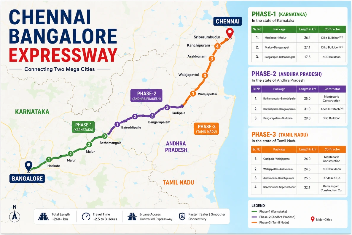 Chennai Bangalore Expressway Route Map
The Chennai-Bangalore Expressway route map shows the alignment of National Expressway 7 (NE-7) connecting Hoskote near Bengaluru with Sriperumbudur near Chennai. The corridor passes through Karnataka, Andhra Pradesh, and Tamil Nadu, creating a high-speed alternative to the existing NH-48 route.
| State | Districts / Key Nodes |
|---|
| Karnataka | Hoskote, Malur, Bangarpet |
| Andhra Pradesh | Chittoor belt (Baireddypalle, Palamaner) |
| Tamil Nadu | Vellore, Ranipet, Arakkonam, Kancheepuram, Sriperumbudur |
Current Status and Opening Date of Chennai-Bangalore Expressway
As of 2026, the Chennai Bangalore Expressway's current status shows partial operational readiness. The 71 km Karnataka stretch from Hoskote to the KGF border has been operational since December 2024, and a 25 km Andhra Pradesh section opened in June 2026, taking the total open length to about 100 km. The remaining Andhra and Chennai-end packages are targeted for October 2026, but the 25.5 km Arakkonam-Kancheepuram stretch is stalled in a contract dispute, pushing full end-to-end opening to early 2027.
| Phase | Stretch | Current Status | Milestone Operational Date |
|---|
| Phase 1: Karnataka | Hoskote to Bethamangala Border (71 km) | 100% Operational | Opened in December 2024 |
| Phase 2: AP (Part A) | Bethamangala to Baireddypalle (25 km) | 100% Operational | Opened in June 2026 |
| Phase 2: AP (Part B) | Baireddypalle to TN Border (~60 km) | 90% Completed | Targeted for October 2026 |
| Phase 3: TN (Packages 1, 2, 4) | Outer Stretches to Sriperumbudur (~80.6 km) | Nearing Completion | Targeted for October 2026 |
| Phase 3: TN (Package 3) | Arakkonam to Kancheepuram Block (25.5 km) | Work Stalled | Projected for Early 2027 |
Toll Charges on Chennai-Bangalore Expressway - Updated 2026
Toll collection is currently active only on the operational Hoskote-Baireddypalle stretch (about 100 km). As per the latest NHAI notification, these are the rates for vehicles utilising the main carriageway.
| Vehicle Type | Single Journey | Return Journey |
|---|
| Car / Jeep / Van | ₹195 | ₹290 |
| LCV / Minibus | ₹315 | ₹470 |
| Bus / Truck (2-axle) | ₹655 | ₹985 |
| Multi-axle vehicles | As per applicable NHAI pro-rata toll rates based on the vehicle class and distance travelled | As per applicable NHAI pro-rata toll rates based on the vehicle class and distance travelled |
The total end-to-end toll for the Chennai-Bengaluru Expressway will be notified upon the project's full opening. Independent estimates suggest the final car toll may range between ₹500- ₹650, but these remain estimates until published in the official government gazette.
Travel Time: Before vs After
The Chennai to Bangalore express highway alters the logistics landscape between the two mega-cities. The reduction in driving hours changes how businesses and families approach interstate travel.
| Scenario | Route | Estimated Travel Time | What Changes |
|---|
| Before Expressway | NH-48 (Current Route) | 5.5-7 hours | Passes through towns, traffic signals, and congested urban stretches. |
| Current (Partially Operational) | NE-7 Operational Stretch + NH-48 | Around 5-6 hours | Uses the operational expressway section before merging back to NH-48, reducing congestion on some stretches. |
| After Full Completion (Expected 2027) | NE-7 (Chennai–Bangalore Expressway) | 2.5-3 hours | Fully access-controlled expressway with uninterrupted travel and significantly reduced journey time. |
Key Interchanges and Exits on Chennai-Bengaluru Expressway
The Bangalore-Chennai Expressway entry and exit points provide seamless connections to major industrial zones and local state highways. Access to places like Malur and Bangarpet has improved significantly from Bangalore.
| Interchange / Exit | State | Connects To |
|---|
| Hoskote (entry point) | Karnataka | Bangalore via Old Madras Road / NH-75 |
| Malur | Karnataka | Malur-Hosur Road / SH-95 |
| Bangarpet | Karnataka | Kolar Gold Fields via SH-96 |
| Bethamangala | Karnataka | Sainsbury / KGF Border |
| Baireddypalle | Andhra Pradesh | Palamaner / Chittoor via NH-42 |
| Arakkonam / Kancheepuram | Tamil Nadu | Tiruttani via NH-716 & SH-58 |
| Sriperumbudur (endpoint) | Tamil Nadu | Chennai via NH-48 |
Important Local Travel Advisory: If you are driving from Bangalore, you must exit the main tollway at Baireddypalle and take NH-42 to bypass the stalled section in Tamil Nadu.
Real Estate Impact of the Chennai Bangalore Expressway
Land and property activity along the corridor began to climb as soon as the alignment was finalised.
| Node | What's Driving Demand | Property Type to Watch |
|---|
| Hoskote (Karnataka) | Expressway origin point, spillover from East Bangalore and Whitefield's housing demand | Residential plots, villa projects |
| Malur-Narasapura (Karnataka) | Major auto and manufacturing hub hosting Honda and Volvo facilities | Industrial-adjacent plots, worker housing |
| Bangarpet-KGF belt (Karnataka) | Industrial spillover from expanding Kolar clusters and dedicated exit ramps | DTCP-approved residential land tracts |
| Chittoor (Andhra Pradesh) | Mega food processing hub status and high-density warehouse demand | Logistics plots, commercial land |
| Ranipet (Tamil Nadu) | Tata Motors-JLR EV plant announcement and Defence Corridor alignment | Rental housing, ancillary unit land |
| Sriperumbudur (Tamil Nadu) | Expressway terminal, established electronics cluster, proximity to Greenfield Airport | Integrated townships, rental apartments |
Note: Infrastructure timelines and property prices carry risk; treat corridor-led appreciation as a long-term play and verify local approvals before purchasing land.
Top Projects Near Chennai Bangalore Expressway
The Chennai Bangalore Expressway master plan has triggered the launch of premium residential layouts near major access nodes. Here are a few notable projects currently available.
Check Latest Projects
Ramky Lumina
Ramky Lumina, Hosa Road, Bangalore, India
Ramky Fortuna
Ramky Fortuna, Whitefield, Bangalore, India
Habulus Tranquil
Habulus Tranquil, Electronic City, Bangalore, India
Aakruthi Roots And Rays
Aakruthi Roots And Rays, Hirandahalli, Bangalore, India
Trifecta Vanto
Trifecta Vanto, Sarjapur Road, Bangalore, India
NBR Soul Of The Seasons
NBR Soul Of The Seasons, Varthur, Bangalore, India
Purva Meraki
Purva Meraki, Somasundra Palya, Bangalore, India
L&T Elara Celestia
L&T Elara Celestia, Hebbal, Bangalore, India
Royal Posch
Royal Posch, Subramanyapura, Bangalore, India
Codename Ultra Hebbal
Codename Ultra Hebbal, Hebbal, Bangalore, India
Find Property Along the Chennai-Bangalore Expressway
The Chennai-Bangalore Expressway is already reshaping property demand at Hoskote, Malur and Sriperumbudur, and corridors like these typically see the strongest appreciation before full completion. If you are exploring plots or homes along the route, NoBroker helps you find verified, zero-brokerage properties in East Bangalore and beyond, before prices catch up with the corridor. As the final sections near completion, acting early ensures you secure prime assets. Exploring developments along the Bangalore-Mysore Expressway can also provide comparative investment insights.
Frequently Asked Questions
Q: Is the Chennai-Bangalore Expressway open? Ans: Yes, the Chennai-Bangalore Expressway is partially open. As of 2026, around 100 km from Hoskote in Karnataka to Baireddypalle in Andhra Pradesh is operational. The remaining sections are under construction, so end-to-end travel on the expressway is not yet possible.
Q: When will the Chennai-Bangalore Expressway be fully completed? Ans: The full Chennai-Bangalore Expressway is expected to be completed in early 2027. Most construction packages are targeted for completion by October 2026, but delays in a section in Tamil Nadu have pushed back the corridor's final opening.
Q: What is the toll for cars on the Chennai-Bangalore Expressway? Ans: Currently, the toll for a car, jeep, or van on the operational 100 km stretch is ₹195 for a single journey and ₹290 for a return trip. The complete end-to-end toll will be officially announced after the entire expressway becomes operational.
Q: Which districts does the Chennai-Bangalore Expressway pass through? Ans: The expressway passes through Hoskote, Malur, and Bangarpet in Karnataka, the Chittoor region in Andhra Pradesh, and Vellore, Ranipet, Arakkonam, Kancheepuram, and Sriperumbudur in Tamil Nadu, connecting several major industrial and logistics hubs.
Q: What will the Bangalore to Chennai travel time be? Ans: Once the Chennai-Bangalore Expressway is fully operational, the travel time between Bengaluru and Chennai is expected to reduce from around 5.5 to 7 hours to approximately 2.5 to 3 hours, making interstate travel significantly faster and more efficient.
Q: Why is the Chennai-Bangalore Expressway delayed? Ans: The primary reason for the delay is a legal dispute over a contract involving the Arakkonam-Kancheepuram package in Tamil Nadu. Issues related to construction materials and contract execution temporarily stalled work, postponing the full opening of the expressway until early 2027.
Builder Projects
NoBroker VIP Plan Brand V1
NoBroker VIP Plan Brand V2
NoBroker VIP Plan Corporate V1
NoBroker VIP Plan Corporate V2
NoBroker Property Carnival Pune
Codename Elite Hinjewadi/ Lodha Hinjewadi Phase 3
Codename Sarjapura / Lodha Codename Sarjapura
Codename Elite Devanahalli / Embassy Springs New Phase
Codename Mittaganahalli / Godrej Thanisandra
Codename Marathahalli / Century Silicon City
Codename Elite Kharadi / Lodha Codename-Kharadi Luxury
Pacifica Aurum Pride Tower
Most Viewed Articles
With a passion for both property and prose, Nivriti crafts compelling content that informs and empowers real estate audiences. She translates complex market trends and investment strategies into clear, engaging articles, blogs, and website copy. Her background in real estate fuels insightful content that resonates with buyers, sellers, and industry professionals alike. When she isn't diving into the latest market data, you might find her exploring hidden gems in the local housing market or curled up with a good book.
Loved what you read? Share it with others!




 ✕
✕


 Full RM + FRM support