Table of Contents
Loved what you read? Share it with others!

Electronic City Metro Station Bangalore: Route, Timings, Fare & Localities to Live in 2026
Updated : February 11, 2026, 6:44 AM
Author :
![]() Suju
Suju
Table of Contents
The Electronic City Metro Station is the newest addition to the Namma Metro route, having started operations on August 10, 2025. Located on the highly anticipated Yellow Line (RV Road—Bommasandra), this elevated station is strategically positioned to serve one of India's largest electronic industrial parks. As the Yellow Line nears completion, the Electronic City Metro Station is poised to speed up and simplify commuting for thousands of IT professionals and residents in South Bangalore.
This station is a critical component of Namma Metro's Phase 2 expansion, designed to integrate Electronic City seamlessly into Bangalore's growing rapid transit system. It will provide much-needed connectivity not just within the city but also improve access to surrounding industrial areas. With modern facilities and planned integration with other transportation modes, the Electronic City Metro Station is set to enhance the quality of life and potentially boost property values in one of Bangalore's most economically significant zones. This guide provides detailed information based on the latest updates and official plans.
Electronic City Metro Station - Quick Information
Get essential details about the upcoming Electronic City Metro Station, Bangalore. Check out the key projected information, including the line, expected opening, route, and planned facilities.
| Station Information | Details |
| Location | Electronic City Phase 1, Near Infosys Campus, Hosur Road, Bangalore |
| Line | Yellow Line (RV Road - Bommasandra) |
| Status | Operational |
| Opened date | August 10, 2025 |
| Operator | Bangalore Metro Rail Corporation Limited (BMRCL) |
| Owned by | Namma Metro |
| Type | Elevated |
| Platforms | Side platformPlatform 1 - Rashtreeya Vidyalaya RoadPlatform 2 - Delta Electronics Bommasandra |
| Platform level | 2 |
| Tracks | 2 |
| Parking | Two-wheeler parking planned (Approx. 1000 spaces); No Car Parking |
| Interchange Stations | RV Road (Green Line), Jayadeva Hospital (Pink Line - U/C), Central Silk Board (Blue Line - U/C) |
| Projected Daily Ridership (Yellow Line) | ~2.5 Lakh + |
| Train Type | Driverless Operation Planned |
| Number of Stations (Yellow Line) | 16 |
| Line Length (Yellow Line) | ~19 km |
| Projected Timings | ~5:00 AM - 11:00 PM (Subject to final schedule) |
| Projected Fare Range | ~₹10 - ₹60 (Distance-based) |
Electronic City Metro Station Map
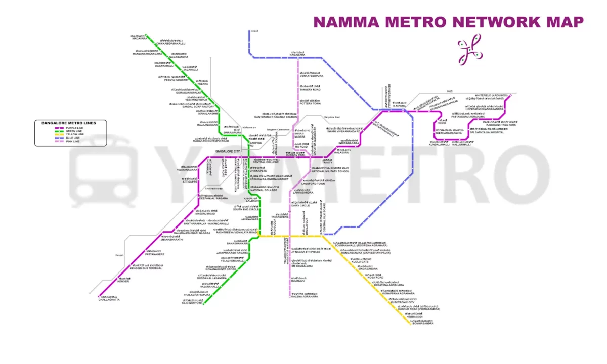
The Electronic City Metro Station map places it strategically on the southern stretch of the Namma Metro Yellow Line. Situated between the Konappana Agrahara station (towards RV Road) and the Huskur Road station (towards Bommasandra), it serves the heart of Electronic City Phase 1. This location provides direct access to numerous tech companies like Infosys and Wipro for employees. The map below illustrates the Yellow Line's route, highlighting Electronic City's connectivity to key interchange points like Central Silk Board and RV Road.
This Electronic City Metro line map visually demonstrates how the station integrates into the larger Namma Metro network, facilitating travel across Bangalore once the line is operational.
Electronic City Metro Station Route Details 2026
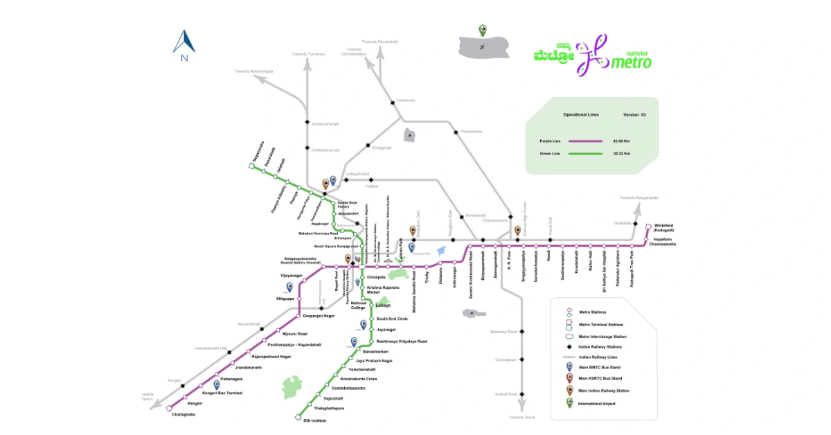
The Electronic City Metro Station is a vital stop on the Namma Metro Yellow Line, which stretches approximately 19 km from RV Road in the south to Bommasandra in the southeast. This entirely elevated line features 16 stations and is designed to significantly improve connectivity to Bangalore's major IT and industrial belt. The Electronic City Metro route will provide a faster, more reliable alternative to road transport, bypassing the congested Hosur Road and Silk Board junctions. The line will feature interchanges with the Green Line at RV Road, the upcoming Pink Line at Jayadeva Hospital, and the upcoming Blue Line (Airport Line via ORR) at Central Silk Board, making travel across different parts of the city much more convenient.
How to Travel From Electronic City Metro Station to Whitefield Metro Station
Reaching Whitefield from Electronic City via metro will involve interchanges once the network is fully operational. A likely route would be: Take the Yellow Line from Electronic City towards RV Road. Alight at Central Silk Board (an upcoming major interchange). Transfer to the Blue Line (Outer Ring Road Line - also under construction) towards KR Puram. Alight at KR Puram. Transfer to the Purple Line towards Whitefield (Kadugodi). Alight at your desired station in Whitefield. This multi-interchange journey highlights the integrated nature of the future metro network.
| Detail | Information (Projected) |
| Approx. Travel Time | 70-90 minutes (depending on interchanges & frequency) |
| Approx. Distance | ~35-40 km |
| Number of Stops | ~25-30 stations (varies with exact route/interchange) |
| Interchanges Needed | Yes (Likely 2-3: Silk Board, KR Puram) |
| Projected Fare | ₹50 - ₹60 (Estimate based on distance) |
| Line(s) Used | Yellow -> Blue (Future) -> Purple |
Nearby Markets and Places (Whitefield):
- Phoenix Marketcity
- VR Bengaluru Mall
- Inorbit Mall
- Forum Shantiniketan Mall
- ITPL (International Tech Park Bangalore)
Best Areas to Live (Near Whitefield):
- Whitefield (Proper)
- Kadugodi
- Hope Farm Junction Area
- Brookefield
- Varthur
Connecting Electronic Metro City Station to Silk Board Metro Station
Connecting to the Central Silk Board interchange from Electronic City will be very straightforward. Simply board the Yellow Line train heading towards RV Road from the Electronic City Metro Station. Central Silk Board is just a few stations away (approx. 5 stops). This short journey is expected to take less than 15 minutes, offering a massive improvement over road travel through the notoriously congested Silk Board junction area. Silk Board will be a crucial interchange connecting the Yellow Line with the upcoming Blue Line (ORR-Airport Line).
| Detail | Information (Projected) |
| Approx. Travel Time | 10-12 minutes |
| Approx. Distance | ~6-7 km |
| Number of Stops | 5 stations |
| Interchanges Needed | No (Direct on Yellow Line) |
| Projected Fare | ₹20 - ₹25 (Estimate based on distance) |
| Line(s) Used | Yellow |
Nearby Markets and Places (Silk Board Area):
- Total Mall (now defunct, area landmark)
- BTM Layout Market Area
- Koramangala Shopping Areas (short auto/bus ride away)
- HSR Layout Sectors (shopping & restaurants)
- Gopalan Innovation Mall (Bannerghatta Road, nearby)
Best Areas to Live (Near Silk Board):
- BTM Layout (Stages 1 & 2)
- HSR Layout (Multiple Sectors)
- Koramangala (Various Blocks)
- Bommanahalli
- Madiwala
How to Travel From Electronic City Metro Station to MG Road Metro Station
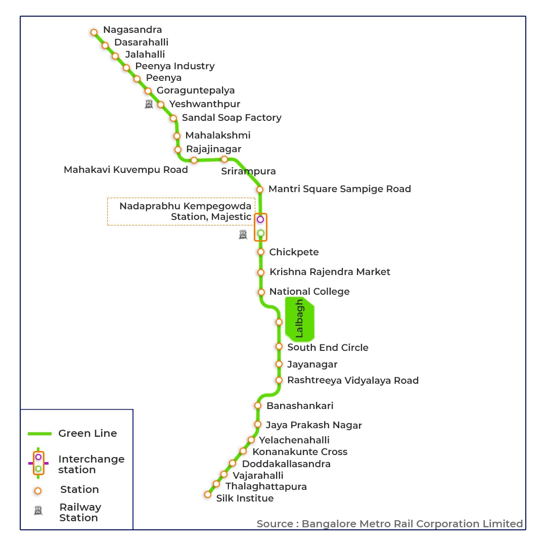
To travel from Electronic City Metro Station to MG Road in the city centre, commuters will need to use interchange facilities. A common route would be: Take the Yellow Line from Electronic City towards RV Road. Alight at RV Road Station. Transfer to the Green Line towards Nagasandra. Alight at Nadaprabhu Kempegowda Station (Majestic). Transfer to the Purple Line towards Whitefield (Kadugodi). Alight at MG Road Station. Once operational, an alternative future route might involve the Pink Line via the Jayadeva Hospital interchange.
| Detail | Information (Projected) |
| Approx. Travel Time | 50-65 minutes |
| Approx. Distance | ~20-22 km |
| Number of Stops | ~20-22 stations |
| Interchanges Needed | Yes (2: RV Road, Majestic) |
| Projected Fare | ₹50 - ₹60 (Estimate based on distance) |
| Line(s) Used | Yellow -> Green -> Purple |
Nearby Markets and Places (MG Road):
- Brigade Road Shopping Street
- Commercial Street (short walk/auto ride)
- MG Road Boulevard (Rangoli Metro Art Center)
- Church Street (Restaurants & Pubs)
- UB City (Luxury Mall)
Best Areas to Live (Near MG Road):
- Ashok Nagar
- Richmond Town
- Langford Town
- Shanthala Nagar
- Lavelle Road / Vittal Mallya Road Area (Premium)
How to Travel From Electronic City Metro Station to Majestic Metro Station
To travel from Electronic City to Majestic Metro, take the Yellow Line metro from the Electronic City metro station. Alight at Rashtreeya Vidyalaya Road. Transfer to the Green Line Metro towards Mysore Road. Alight at Nadaprabhu Kempegowda Metro Station.
| Detail | Information (Projected) |
| Approx. Travel Time | 30-40 minutes |
| Approx. Distance | ~17-20 km |
| Number of Stops | ~19 stations |
| Interchanges Needed | Yes (1: RV Road) |
| Projected Fare | ₹55 - ₹65 (Estimate based on distance) |
| Line(s) Used | Yellow -> Green |
Nearby Markets and Places (Majestic):
- Chickpet Market
- KR Market
- Commercial Street
- Church Street
- UB City
Best Areas to Live (Maestic):
- Sheshadripuram
- Sampangiram Nagar
- Gandhi Nagara
- MG Road
- Malleshwaram
Electronic City Metro Station Platform Details
The Electronic City Metro Station will be an elevated station featuring two platforms, facilitating travel in both directions along the Yellow Line. While exact platform configurations (side or island) are finalised during construction, typically:
- Platform 1 (Tentative): Trains towards Bommasandra (Southern Terminus). The next station in this direction would be Huskur Road.
- Platform 2 (Tentative): Trains towards Rashtreeya Vidyalaya Road (RV Road) (Northern Terminus). The next station in this direction would be Konappana Agrahara.
The station has modern amenities, including elevators, escalators, staircases, ticketing counters, automated fare collection (AFC) gates, and clear signage, to ensure passenger convenience and accessibility. Facilities for differently abled passengers will also be incorporated as per BMRCL standards.
Electronic City Metro Station List Towards Bommasandra (Platform 1 - Tentative)
From Electronic City Metro Station, travelling south on the Yellow Line towards the Bommasandra terminus involves the following stations:
- Electronic City
- Huskur Road
- Hebbagodi
- Bommasandra (Terminus)
This section connects the main Electronic City hub with further industrial areas and the end of the Yellow Line.
Electronic City Metro Station List Towards RV Road (Platform 2 - Tentative)
From Electronic City Metro Station, travelling north on the Yellow Line towards the RV Road terminus involves the following stations:
- Electronic City
- Konappana Agrahara
- Beratena Agrahara
- Hosa Road
- Singasandra
- Kudlu Gate
- Hongasandra
- Bommanahalli
- Central Silk Board (Interchange with Blue Line - U/C)
- BTM Layout
- Jayadeva Hospital (Interchange with Pink Line - U/C)
- Ragigudda
- Rashtreeya Vidyalaya Road (RV Road) (Interchange with Green Line & Terminus)
This route connects Electronic City to key junctions like Silk Board and RV Road, enabling access to other metro lines and parts of South Bangalore.
Electronic City Metro Station Timings Details
The Electronic City Metro timings are expected to align with the standard Namma Metro operational hours once the Yellow Line commences service (projected mid-2025). Based on current network operations, the tentative schedule would be:
- Monday to Saturday: 5:00 AM to 11:00 PM (approx.)
- Sundays & Public Holidays: 7:00 AM to 11:00 PM (approx.)
Frequency:
- Initial Operations: Due to the phased delivery of train sets, train frequency might be lower initially (possibly every 20-30 minutes).
- Full Operations: Frequency is expected to improve significantly as more trains are inducted. The aim is for a peak hour frequency of 4-6 minutes and an off-peak frequency of 10-15 minutes.
These timings are projections and subject to official confirmation by BMRCL upon launch.
Electronic City Metro Station Ticket Fares
Ticket fares for the Electronic City Metro Station will follow Namma Metro's distance-based fare structure. Below are the ticket fares:
- Minimum Fare: ₹10
- Maximum Fare (on Yellow Line): Likely up to ₹60 (for travel between RV Road and Bommasandra)
- Fare Calculation: Fares increase based on the number of stations or distance travelled. Travelling to interchange stations and transferring to other lines (Green, Purple, and future Pink/Blue) will incur fares based on the total distance from the origin to the destination.
Payment Methods: Commuters will be able to use:
- Tokens: For single journeys.
- Smart Cards (Varshik): Rechargeable cards offering a discount (currently 5%) on fares.
- NCMC Cards/QR Tickets: Potentially available via mobile apps, aligning with newer ticketing options.
Electronic City Metro Station Entry & Exit Points
Specific details about the number and location of entry/exit gates at the Electronic City Metro Station will be available closer to the station's opening. However, being a major station serving a high-traffic area, it is expected to have multiple access points strategically located for easy entry and exit.
- Access points are likely to connect directly to Hosur Road.
- Potential skywalks or connections towards major company campuses (like Infosys).
- Integration with BMTC bus stops and potentially auto-rickshaw stands.
For accessibility, the station will have standard facilities like elevators and escalators at entry/exit points.
Electronic City Metro Station Parking Details
A significant point regarding Electronic City Metro Station parking is that the BMRCL's current plans include only two-wheeler parking. Due to space constraints along the Yellow Line corridor, car parking facilities are not planned at most stations, including Electronic City.
| Parking Details | Information (Planned) |
| Vehicle Type | Two-Wheelers Only |
| Car Parking | Not Available |
| Approx. Capacity | ~1000 two-wheelers (Largest on Yellow Line) |
| Projected Daily Fee | ₹30 (Maximum per day) |
| Projected Hourly Fee | ₹15 (For the first 4 hours - TBC) |
| Monthly Pass | Likely to be available (details awaited) |
| Security | Expected CCTV surveillance, personnel |
This lack of car parking might be a concern for commuters who drive to the station. Planning last-mile connectivity via buses, autos, ride-sharing, or walking will be essential for those needing to reach the station.
Best Areas to Live Near Electronic City Metro Station
Living near the upcoming Electronic City Metro Station offers excellent connectivity to Bangalore's key destinations while providing a blend of residential options suited to the tech hub's lifestyle. The surrounding neighbourhoods are well-equipped with amenities, making them ideal for the area's workforce and families. Here are the top 5 residential areas near the station:
1. Electronic City Phase 1, Bangalore
- Distance from station: 0-2 km (Walkable for many parts)
- Property types: Primarily high-rise apartments, PGs, and some company guest houses.
- Key features: Heart of the IT park, walk-to-work potential for many, direct metro access, numerous eateries and shops.
- Average Rent (Approx. Early 2025): High-demand area. PGs are abundant. 1 BHK apartments might range from ₹14,000 - ₹22,000. 2 BHKs in complexes typically start from ₹30,000 - ₹50,000+. 3 BHKs often range from ₹45,000 - ₹75,000+.
2. Konappana Agrahara, Bangalore
- Distance from station: 0-2 km (Adjacent to the station)
- Property types: Mix of apartments (newer developments), independent houses, PGs.
- Key features: Extremely close to the metro station, rapid development, proximity to major companies (Infosys, etc.).
- Average Rent (Approx. Early 2025): Similar to E-City Phase 1 due to proximity. 1 BHK: ₹12,000 - ₹20,000. 2 BHK: ₹25,000 - ₹45,000+. 3 BHK: ₹40,000 - ₹70,000+.
3. Electronic City Phase 2, Bangalore
- Distance from station: 2-4 km
- Property types: Apartments in gated communities, some villas, and independent houses.
- Key features: It is a well-established residential area within the E-City complex, slightly quieter than Phase 1, and has good social infrastructure.
- Average Rent (Approx. Early 2025): Slightly more varied. 1 BHK: ₹10,000 - ₹18,000. 2 BHK: ₹20,000 - ₹38,000. 3 BHK: ₹30,000 - ₹60,000+.
4. Neeladri Nagar, Bangalore
- Distance from station: 2-4 km
- Property types: Well-known for independent houses and villas, plus apartment complexes.
- Key features: Established layout within Electronic City, known for better greenery and planning than some surrounding areas.
- Average Rent (Approx. Early 2025): Can range significantly. Apartments: 1 BHK: ₹12,000 - ₹20,000, 2 BHK: ₹22,000 - ₹40,000. Independent houses/villas command higher rents, starting from ₹40,000+ for a 3 BHK.
5. Hebbagodi, Bangalore
- Distance from station: 3-5 km (Served by the next metro station towards Bommasandra)
- Property types: Rapidly growing area with many new large apartment complexes, some older independent houses.
- Key features: An upcoming residential hub, potentially more affordable than core E-City, good connectivity via Hosur Road, and a future metro stop.
- Average Rent (Approx. Early 2025): Often offers value. 1 BHK: ₹8,000 - ₹15,000. 2 BHK: ₹15,000 - ₹30,000. 3 BHK in newer complexes: ₹25,000 - ₹45,000+.
Why Invest Near Electronic City Metro Station?
Here are the key reasons why investing near the Electronic City Metro Station is a smart choice for homebuyers and property investors in Bangalore.
Convenience & Connectivity
Residents near Electronic City Metro Station will enjoy seamless connectivity to central business districts, educational institutions, and entertainment hubs. The station's strategic location on the Yellow Line ensures quick access to RV Road, Silk Board, and easy interchanges to Green, Purple (and future Pink, Blue) lines connecting to Majestic, MG Road, Whitefield, Yeshwanthpur, and eventually the Airport. The metro will drastically cut down commute times, bypassing notorious traffic jams on Hosur Road.
Potential Property Value Boost
Historically, Bangalore's proximity to operational metro stations has led to significant appreciation in property values and rental rates (often 20-40% higher than comparable properties further away). The anticipated opening of the Electronic City Metro Station will drive real estate demand in surrounding localities like Electronic City Phases 1 & 2, Konappana Agrahara, Hebbagodi, and nearby areas, making it attractive for end-users and investors.
Target Audience & Property Types
The area caters to diverse residential preferences:
- IT Professionals: Studio apartments and 1-2 BHK units.
- Families: 2-3 BHK apartments and villas in gated communities.
- Premium buyers: Luxury apartments and villas in select layouts.
- Investment options: Apartments in new complexes and plotted developments further out..
A New Era of Connectivity for Electronic City
The Electronic City Metro Station is more than just another stop on the Namma Metro map; it represents a crucial step towards integrating Bangalore's primary IT hub into the city's rapid transit network. As part of the upcoming Yellow Line, this station holds immense potential to transform daily commutes, alleviate road congestion, and spur further regional development. Although the Electronic City Metro opening has faced delays, the enhanced connectivity coupled with planned facilities, promises a significant upgrade in convenience.
Frequently Asked Questions
Ans: Konnapana Agrahara metro station is the nearest metro station to Electronic City.
Ans: The Electronic City Metro Station, part of the Yellow Line, started operation on August 10, 2025.
Ans: Yes, parking is planned, but only for two-wheelers. BMRCL reports indicate a large facility with a capacity for approximately 1000 two-wheelers is planned. Due to space constraints, there are no plans for car parking at this station.
Ans: The Yellow Line (Line-3) of Namma Metro will connect to Electronic City. This line runs from RV Road to Bommasandra.
Ans: Trains usually run from 5:30 AM to 11:00 PM, with a frequency of about 5–10 minutes.
Recommended Reading
Bangalore Metro: Map Route, Timings, Lines, Stations List and Updated News 2026
May 4, 2025
489482+ views

Purple Line Metro Bangalore: Routes, Maps and Timings and Fares
May 1, 2025
271222+ views
Yellow Line Metro Bangalore: Route, Map Timings, Stations and Fares in 2026
May 2, 2025
258502+ views
The Green Line Metro Bangalore: Routes, Maps, fares and Nearby Residential Areas
April 10, 2025
225590+ views
Yeshwanthpur Metro Station Bangalore: Map, Routes, Parking, Facilities, and Travel Tips 2026
January 7, 2025
171884+ views
Most Viewed Articles
Bangalore Metro: Map Route, Timings, Lines, Stations List and Updated News 2026
May 4, 2025
489482+ views
Top 12 Richest Cities in India: Population, Area, GDP and Ranking in 2026
March 13, 2025
355573+ views
Purple Line Metro Bangalore: Routes, Maps and Timings and Fares
May 1, 2025
271222+ views
Yellow Line Metro Bangalore: Route, Map Timings, Stations and Fares in 2026
May 2, 2025
258502+ views
The Green Line Metro Bangalore: Routes, Maps, fares and Nearby Residential Areas
April 10, 2025
225590+ views
 Author
Loved what you read? Share it with others!
Recent blogs in
Sarojini Nagar Metro Station, Routes, Fares, Amenities, and Nearby Areas in 2026
March 18, 2026 by Suju
List of 10 Best Schools in HSR Layout, Bangalore: Annual Fees, Board and Facilities for 2026-27
March 9, 2026 by NoBroker.com


 Full RM + FRM support

Join the conversation!