Table of Contents
Loved what you read? Share it with others!
Bangalore Metro: Map Route, Timings, Lines, Stations List and Updated News 2026
Updated : February 10, 2026, 3:58 PM
Author :
Srivalli.susarla
Table of Contents
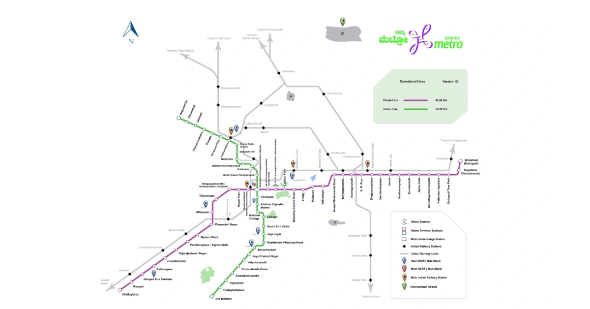
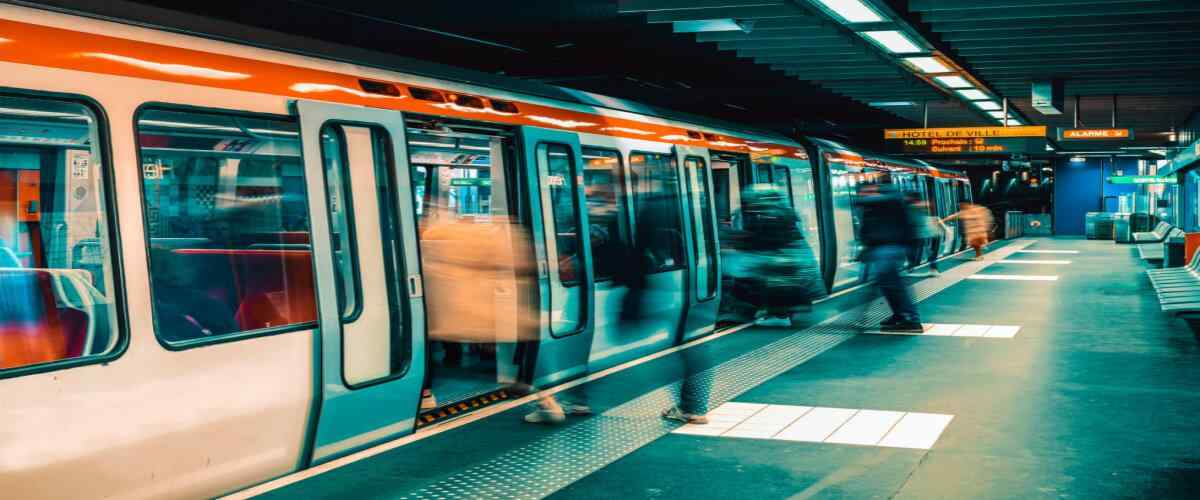
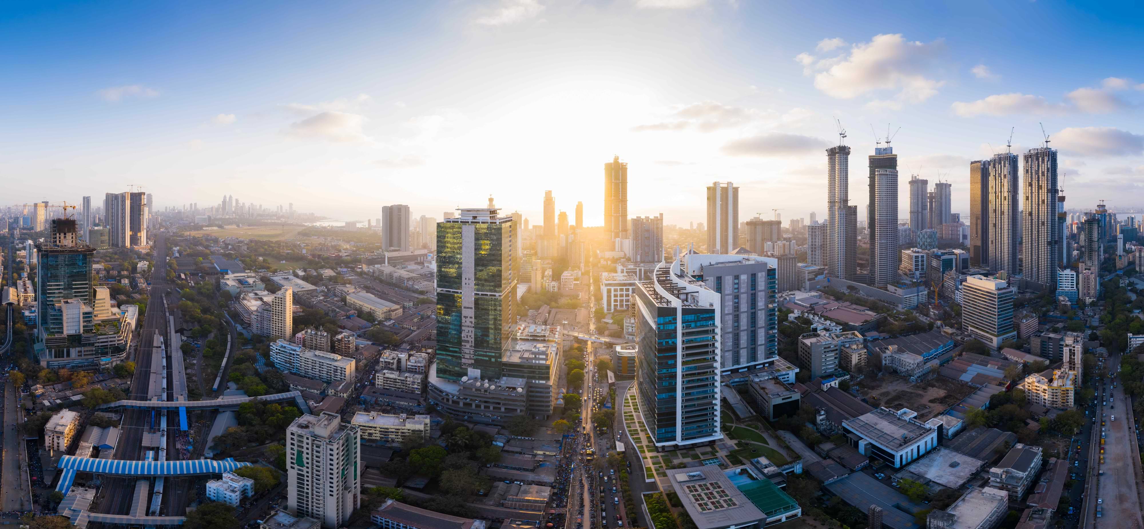
Bangalore Metro, known as Namma Metro, is India's second-largest metro system, expanding its network to revolutionise urban mobility in Bengaluru. Spanning 74 km with 66 stations, it provides a cost-effective and reliable alternative to chaotic and costly road transport. Currently undergoing significant expansion, the metro network is set to grow with an additional 102 km of lines under construction and 82 km soon to commence.
The Yellow Line, from RV Road to Bommasandra, is on the brink of operation and is awaiting the delivery and testing of new trains. Extensions like the Green Line to Madavara and the development of the Pink and Blue Lines mark the progress towards Phase 3 and 4 expansions. With its first-ever profit in 2022-23, Bangalore Metro aims to enhance city-wide connectivity. It focuses on increasing non-fare revenue, backed by PM Gati Shakti's plan for rapid infrastructure development.
Namma Bangalore Metro Route 2026 - Quick Info
| Aspect | Information |
| Owner | Bangalore Metro Rail Corporation Limited (BMRCL) |
| Locale | Bangalore, Karnataka, India |
| Transit Type | Rapid transit |
| Lines | Purple Line, Green Line, Yellow Line (under construction), Pink Line (under construction), Blue Line (under construction), Orange Line (under planning), Grey Line (under planning), Red Line (under planning) |
| Number of Stations | Underground sections, elevated stations, the first metro in South India with an underground section, rainwater harvesting, solar installations at depots, free Wi-Fi service, emergency communication systems, and integrated control centres |
| Daily Ridership | 66 operational (74 km), an additional 102 km under construction and 82 km soon to commence |
| Annual Ridership | 232.8 million (2023) |
| System Length | 73.75 km operational, 98.26 km under construction (Ph 2, 2A, 2B) |
| Train Length | 6 coaches |
| Top Speed | 80 km/h |
| Operational Hours | 05:00 - 24:00, with frequency between 5-15 minutes |
| Electrification | 750 V DC third rail |
| First Operation | 20 October 2011 |
| Purple Line | 42.17 km, 37 stations, Whitefield to Challaghatta |
| Green Line | 30.5 km, 30 stations, Nagasandra to Silk Institute |
| Yellow Line | 18.82 km, 16 stations, RV Road to Bommasandra (under construction) |
| Blue Line | 58.19 km, 30 stations, KR Puram to Central Silkboard (under construction) |
| Pink Line | 21.386 km, 18 stations, Kalena Agrahara to Nagawara (under construction) |
| Orange Line | 31 km, 22 stations, JP Nagar to Hebbal (under planning) |
| Key Interchange Stations | Majestic (interchange for Purple and Green Lines), RV Road (Yellow Line interchange with Green Line), Silk Board (Yellow Line interchange with Blue Line), Jayadeva Hospital (Yellow Line interchange with Pink Line) |
| Fare Structure | Minimum Rs 10, maximum Rs 60-100 depending on distance |
| Future Expansion Plans | Phase 3 (124 km proposed), including ORR-West Line, airport line, and additional extensions. The total projected cost is around ₹30,000 crore for Phase 2, with a significant portion funded by the state, central government, and international loans. |
| Contactless Payments | QR tickets via Namma Metro app, smart cards available for discounted travel |
| Special Features | Underground sections, elevated stations, the first metro in South India with an underground section, rainwater harvesting, solar installations at depots, free Wi-Fi service, emergency communication systems, and integrated control centres |
| Green, Purple, Yellow, Blue, Pink Line Metro Map Bangalore PDF | Download Bangalore Metro Map PDF |
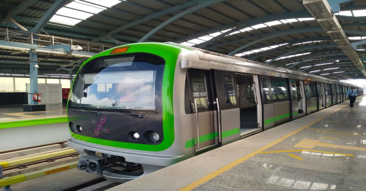
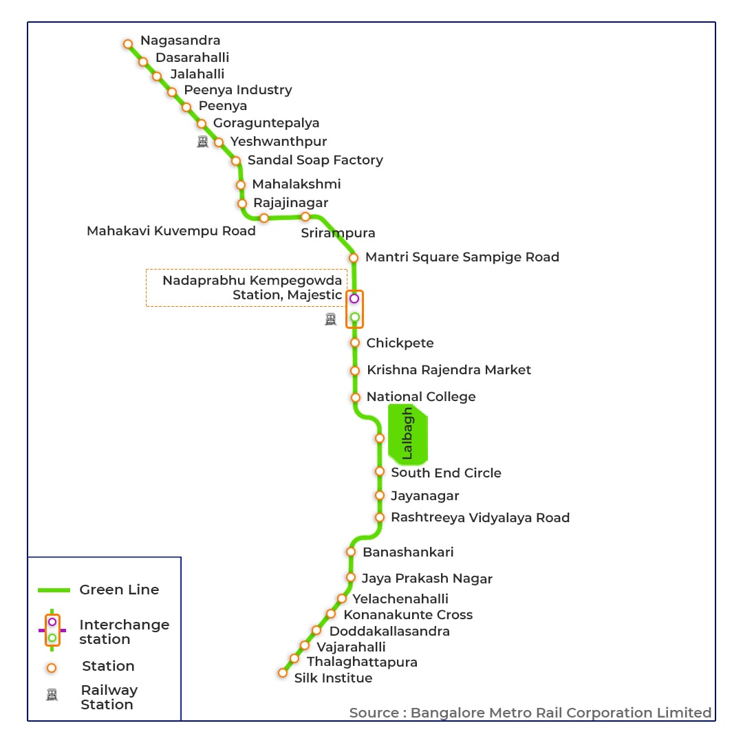
Green Line Metro Map Bangalore

The 30.5km long Green Line connects the North and South parts of Bangalore from Nagasandra to Silk Institute. There are 30 metro stations on this route. The notable stations include Mantri Square Sampige Road, Rajajinagar, and K.R. Market.
How many stations are there on the Bangalore Green Line Metro?
Here are the 32 stations and their interchanging stations:
| Station Name | Transit Station/Interchange Station |
| Madavara | - |
| Chikkabidarakallu | - |
| Manjunathanagara | - |
| Nagasandra | - |
| Dasarahalli | - |
| Jalahalli | Basaveshwara Bus Station |
| Peenya Industry | - |
| Peenya | - |
| Goraguntepalya | Orange Line (Planned) |
| Yeshwanthpur | Yeswanthpur Railway Station |
| Sandal Soap Factory | Yeshwanthpur TTMC |
| Mahalakshmi | - |
| Rajajinagara | - |
| Mahakavi Kuvempu Road | - |
| Srirampura | - |
| Mantri Square Sampige Road | - |
| Nadaprabhu Kempegowda Station, Majestic | Purple Line,Kempegowda Bus Station, KSR City Railway Station |
| Chikkapete | - |
| Krishna Rajendra Market | - |
| National College | - |
| Lalbagh | - |
| South End Circle | - |
| Jayanagara | Jayanagar TTMC |
| Rashtreeya Vidyalaya Road | Yellow Line (Under Construction) |
| Banashankari | Banashankari TTMC |
| Jayaprakash Nagara | Orange Line (Planned) |
| Yelachenahalli | - |
| Konanakunte Cross | - |
| Doddakallasandra | - |
| Vajarahalli | - |
| Thalaghattapura | - |
| Silk Institute | - |
What are the timings and frequency of the Green Line Bangalore Metro?
| Day of the Week | Bangalore metro starting time and ending time | Frequency |
| Monday to Friday | 5:00 AM to 11:00 PM | Every 5 - 15 minutes |
| 2nd and 4th Saturdays & Public Holidays | 5:00 AM to 11:00 PM | Every 8 - 15 minutes |
| 1st, 3rd, and 5th Saturdays | 5:00 AM to 11:00 PM | Every 5 - 15 minutes |
| Sundays | 7:00 AM to 11:00 PM | Every 8 - 15 minutes |
What are the fares for the Bangalore Green Line Metro?
The Green Line Metro's fare structure is designed with affordability in mind, starting at a modest Rs. 10 and capped at a maximum of Rs. 60.
Purple Line Metro Bangalore Map 2026

The Purple Line of Namma Metro is a commuter's dream. It offers a quick and affordable way to travel 39.4 km across Bangalore from Whitefield to Challaghatta in approximately one hour. With 37 conveniently located stations, including a key interchange at Majestic Station with the Green Line, getting around the city has never been easier.
Since its inauguration in 2011, the line has become a go-to for daily commuters seeking to avoid the city's notorious traffic jams. Phase II expansion, set for completion in 2024, promises to make your journey even more seamless.
How many stations are there on the Bangalore Purple Line Metro?
Here are the 37 stations and their interchange stations:
| Station Name | Transit Station/Interchange Station |
| Whitefield | Whitefield railway station/Kadugodi Bus Stand |
| Channasandra | - |
| Kadugodi | - |
| Pattandur Agrahara | - |
| Sadaramangala | - |
| Nallurhalli | Whitefield TTMC |
| Kundalahalli | - |
| Sitharama Palya | - |
| Hoodi Junction | - |
| Garudacharpalya | - |
| Mahadevapura | - |
| Krishnarajapuram | Blue Line (Planned, Ph-2A)/KR Puram Railway Station |
| Benniganahalli | - |
| Baiyappanahalli | Baiyappanahalli Railway Station |
| Swami Vivekananda Road | - |
| Indiranagar | - |
| Halasuru | - |
| Trinity | - |
| MG Road | Pink Line (UC) |
| Cubbon Park | - |
| Dr BR Ambedkar Station | - |
| Sir M Visvesvaraya Station | - |
| Nadaprabhu Kempegowda station, Majestic Line | Green Line/KG Bus Station City Railway Station |
| City Railway Station | City Railway Station |
| Magadi Road | - |
| Balagangadharanatha Swamiji Station, Hosahalli | - |
| Vijayanagara | - |
| Attiguppe | Vijayanagar TTMC |
| Deepanjali Nagara | - |
| Mysore Road | Orange Line(Planned, Phase lll) |
| Nayandahalli | - |
| Rajarajeshwari Nagara | - |
| Jnanabharathi | Jnanabharathi |
| Pattanagere | - |
| Mailasandra | Kengeri TTMC |
| Kengeri Bus Terminal | - |
| Challaghatta | - |
What are the timings and frequency of the Purple Line Bangalore Metro?
| Day of the Week | Timings | Frequency |
| Monday to Friday | 5:00 AM to 11:05 PM | Every 4.5 - 15 minutes |
| 2nd and 4th Saturdays & Public Holidays | 5:00 AM to 11:05 PM | Every 8 - 15 minutes |
| 1st, 3rd, and 5th Saturdays | 5:00 AM to 11:05 PM | Every 4.5 - 15 minutes |
| Bangalore Metro timings on Sunday | 7:00 AM to 11:05 PM | Every 8 - 15 minutes |
What are the fares for the Namma Bangalore Purple Line Metro
The fare structure for the Purple Line Metro is designed to be affordable, beginning at a minimum of Rs. 10 and reaching a maximum of Rs. 60-100.
Yellow Line Metro Bangalore Map 2026
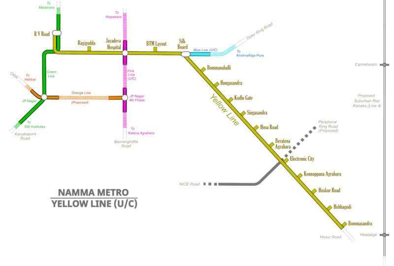
The Yellow Line of Bangalore's Namma Metro, stretching for 18.82 km (11.69 mi), is a completely elevated route linking R.V. Road and Bommasandra. This line is designed with 16 stations, facilitating interchange options with the Green Line at R.V. Road, the Blue Line at Silkboard, and the Pink Line at Jayadeva Hospital.
Currently in its construction phase, the Yellow Line is on track to commence operations by the close of 2023, signifying a significant enhancement in the connectivity and transportation options within the city.
What are the stations on the Namma Bangalore Yellow Line Metro?
Here are the names of 16 Yellow Line metro stations in Bangalore.
| Station Name | Transit Station/Interchange Station |
| Rashtreeya Vidyalaya Road (RV Road) | Interchange station with the Green Line |
| Ragigudda | - |
| Jayadeva Hospital | Future interchange station with the Pink Line |
| BTM Layout | - |
| Central Silk Board | Future interchange station with the Blue Line |
| Bommanahalli | - |
| Hongasandra | - |
| Kudlu Gate metro station | - |
| Singasandra | - |
| Hosa Road | - |
| Beratena Agrahara | - |
| Electronic City | - |
| Konnapana Agrahara | - |
| Husker Road | - |
| Hebbagodi | - |
| Metro station near Bommasandra | - |
Blue Line Metro Bangalore Map Route
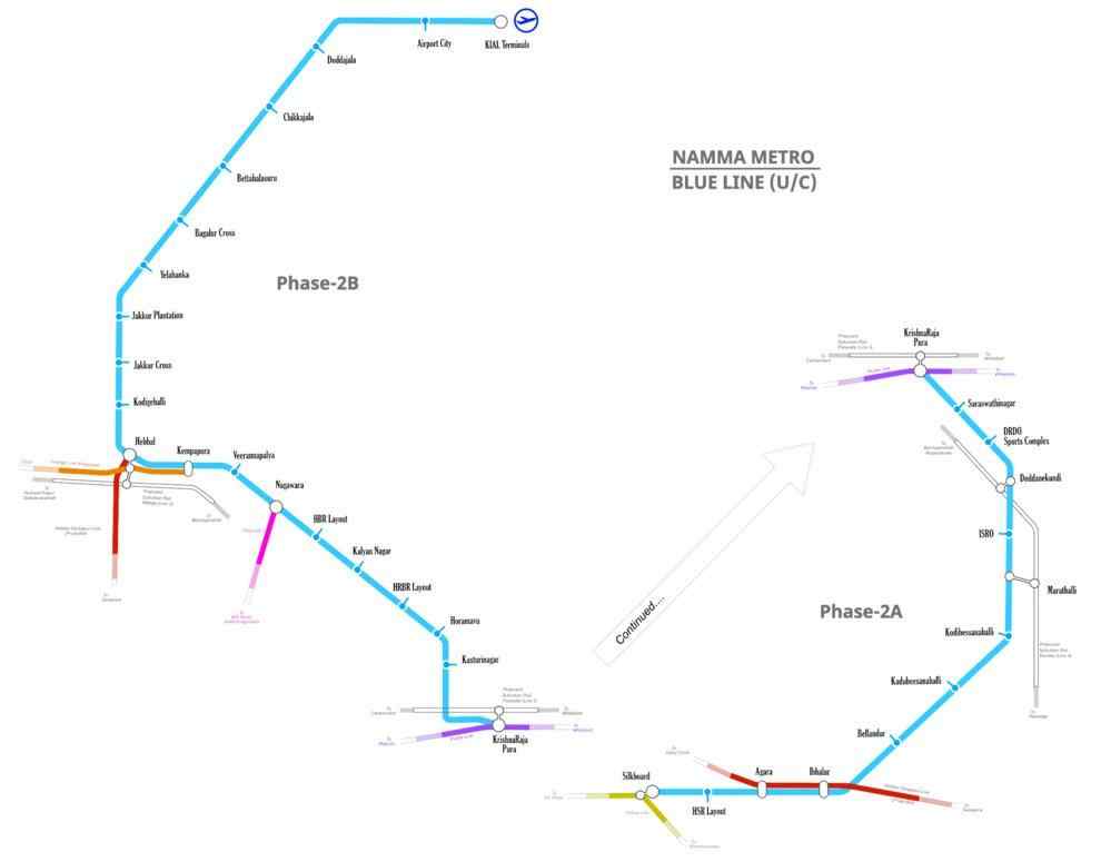
The Blue Line of the Namma Metro in Bangalore, India, is a proposed elevated metro route spanning 18.236 km from KR Puram to Central Silkboard. The line will include 13 stations including some of the prominent localities like HSR Layout, Bellandur, and Mahadevpura which not only hold significant roles in Bangalore's landscape but are also prized as elite residential areas. Trains on the Blue Line will be stabled and maintained at the existing Baiyappanahalli Depot.
BMRCL plans to procure 120 coaches for the Blue Line, with trains operating in a six-coach formation. Due to the re-purposing of some of the Purple Line's stabling lines for the Blue Line, a new depot for the Purple Line will be constructed at Kadugodi near Hope Farm Junction, where government land is available.
Eventually, the Baiyappanahalli Depot will exclusively serve the Blue Line's trains, while the Purple Line's trains will be stabled and maintained at the Kadugodi and Challaghatta Depots.
What are the stations on the Namma Bangalore Blue Line Metro?
Change the list of metro stations into table (Station Name, Interchange & Connections)
| Station Name | Transit Station/Interchange Station |
| KR Puram | Purple Line (under construction) |
| Mahadevpura | - |
| DRDO Sports Complex | - |
| Doddanakundi | - |
| ISRO | - |
| Marathahalli | - |
| Kodibisanahalli | - |
| Kadubeesanahalli | - |
| Bellandur | - |
| Ibbalur | - |
| Agara Lake | - |
| HSR Layout | - |
| Silk Board | Yellow Line (upcoming) |
Pink Line Metro Map Bangalore
The "Pink Line” is one of the proposed lines for the Namma Metro in Bangalore, India, also known as the Bangalore Metro. The Pink Line is planned to cover a length of 21.386 km and is under construction. It is intended to be a combination of both elevated (7.501 km) and underground (13.885 km) tracks, with 18 stations planned along the route. including some of the prominent localities like IIM-Bangalore, MG Road, and Cantonment. The depot for the Pink Line is slated to be located at Kothanur, spread over an area of 31.5 acres.
What are the stations on the Namma Bangalore Pink Line Metro?
Here are the names of 18 Pink Line metro stations in Bangalore.
| Station Name | Transit Station/Interchange Station |
| Nagawara | Blue Line(Under construction) |
| Kadugundanahalli | - |
| Venkateshpura | - |
| Tannery Road | - |
| Pottery Town | - |
| Cantonment Railway Station | Parijaata(Bengaluru Cantonment) |
| Shivajinagar | - |
| Mahatma Gandhi Road | Purple Line |
| National Military School | - |
| Langford Town | - |
| Lakkasandra | - |
| Dairy Circle | Red Line(Proposed) |
| Tavarekere | - |
| Jayadeva Hospital | Yellow Line(Under construction) |
| Jayaprakash Nagar 4th Phase | Orange Line |
| IIMB | - |
| Hulimavu | - |
| Kalena Agrahara | - |
Orange Line Metro Bangalore
The Orange Line (officially known as the ORR-West Line) is a proposed line that will become part of Namma Metro's network in the city of Bangalore, Karnataka, India. It is part of Phase 3A of Namma Metro, which is expected to be operational by 2028-29.
The Orange Line will be an elevated corridor with 22 planned stations. It will run for a distance of 31 kilometres along the Outer Ring Road (ORR) from JP Nagar to Hebbal. The line will also have an interchange with the Blue Line at Hebbal.
Alongside boosting infrastructure, the Orange Line's route through some of Bangalore's top residential areas is set to enhance property values. By offering efficient and comfortable commuting options, this new line will further increase the allure of these already desirable neighbourhoods for residents and potential homebuyers alike.
What are the stations on the Namma Bangalore Orange Line Metro?
Here are the names of 22 Orange Line metro stations in Bangalore.
| Station Name | Transit Station/Interchange Station |
| Kempapura | Blue Line (Under construction) |
| Hebbala | Blue Line (Under construction)Red Line(Approved) |
| Nagashetty halli | - |
| BEL Circle | - |
| Bahubhali Nagar | - |
| Goraguntepalya | Green Line |
| Kanteerava Studio | - |
| Freedom Fighters Cross | - |
| Chowdeshwari Nagara | - |
| Sumanahalli Cross | Grey Line |
| Nagarbhavi BDA Complex | - |
| Dr. Ambedkar Institute of Technology | - |
| Vinayaka Layout | - |
| Nagarabhavi Circle | - |
| Mysuru Road | Purple Line |
| PES University | - |
| Hosakerahalli Cross | - |
| Kamakya Bus Depot | - |
| Kadirenahalli Cross | - |
| Jaya Prakash Nagar | Green Line |
| JP Nagar 5th Phase | - |
| JP Nagar 4th Phase | Pine Line |
Namma Metro's Future: Upcoming Stations & Route Extensions in Bangalore
Bangalore’s Namma Metro is going through constant and significant development. TheFederation of Indian Chambers of Commerce & Industries (FICCI) are planning to add 4 new metro corridors, to be put-to-use by 2032. Here are some of the upcoming metro stations and areas they are connecting with.
| Line Name | Connecting Station | Estimated Launch |
| Yellow Line | Rashtreeya Vidyalaya Road - Bommasandra | July 2025 |
| Pink Line | Kalena Agrahara - Dairy Circle | December 2025 |
| Pink Line | Dairy Circle - Nagawara | December 2026 |
| Blue Line | Central Silk Board - Krishnarajapura | Juen 2026 |
| Blue Line | Krishnarajapura - Hebbala | December 2026 |
| Blue Line | Hebbala - KIAL Terminals | September 2026 |
| Orange Line | Kempapura- JP Nagar 4th Phase | 2029 |
| Grey Line | Hosahalli - Kadabagere | 2029 |
| Red Line | Hebbala - Sarjapur | NA |
Bangalore Metro Latest Updates
Bangalore Metro is expected to launch its yellow line partially in June 2025 and fully in September 2025. The BMRCL also plans to launch more metro lines to connect eight more locations with the metro. The Blue Line commuters can see a new line connecting Central Silk Board to KR Pura via the Outer Ring Road, which will be open by 2026.
How to Buy Tickets for the Bangalore Metro?
Via Namma Metro app
- Download and install the Namma Metro app from the Google Play Store or Apple App Store.
- Create an account and sign in.
- Select the "Buy Ticket" option.
- Select the origin and destination stations.
- Select the number of tickets and the type of ticket (single journey or day pass).
- Review the ticket details and proceed to payment.
- Once the payment is successful, you will receive a QR code ticket.
Via WhatsApp
- Save the BMRCL's WhatsApp chatbot number 8105556677 to your contact list.
- Send "Hi" to the chatbot.
- Select the "Buy Ticket" option.
- Select the origin and destination stations.
- Select the number of tickets and the type of ticket (single journey or day pass).
- Review the ticket details and proceed to payment.
- Once the payment is successful, you will receive a QR code ticket.
Smart Cards
Smart cards are rechargeable cards that can be used to travel on the metro. Smart cards can be purchased from the customer care counters at metro stations. To recharge a smart card, you can use the Namma Metro app, WhatsApp, or the customer care counters.
To use a smart card to enter the metro station, tap the card on the reader at the Automated Fare Collection (AFC) gate. The fare will be deducted from the card balance. To exit the metro station, tap the card on the reader at the AFC gate again.
Cash Payment
Cash payments can be made at the customer care counters at Bangalore metro stations. To purchase a ticket using cash, simply tell the cashier the origin and destination stations. The cashier will give you a token. To enter the metro station, insert the token into the slot at the AFC gate. To exit the metro station, simply walk through the exit gate.
Namma Metro's Future: Upcoming Stations & Route Extensions in Bangalore
Bangalore’s Namma Metro is constantly and significantly developing. The Federation of Indian Chambers of Commerce & Industries (FICCI) is planning to add four new metro corridors to be put to use by 2032. Here are some of the upcoming metro stations and areas they will connect with.
| Line Name | Connecting Station | Estimated Launch |
| Yellow Line | Rashtreeya Vidyalaya Road - Bommasandra | July 2025 |
| Pink Line | Kalena Agrahara - Dairy Circle | December 2025 |
| Pink Line | Dairy Circle - Nagawara | December 2026 |
| Blue Line | Central Silk Board - Krishnarajapura | Juen 2026 |
| Blue Line | Krishnarajapura - Hebbala | December 2026 |
| Blue Line | Hebbala - KIAL Terminals | September 2026 |
| Orange Line | Kempapura- JP Nagar 4th Phase | 2029 |
| Grey Line | Hosahalli - Kadabagere | 2029 |
| Red Line | Hebbala - Sarjapur | NA |
Bangalore's Namma Metro Under-Construction Lines
Bangalore’s Namma Metro is expanding rapidly through Phase 2 and Phase 3, adding over 130 km of new routes to improve city-wide connectivity.
Phase 2: Under Construction:
- Pink Line: Kalena Agrahara to Nagawara (21.25 km, mostly underground)
- Yellow Line: RV Road to Bommasandra (19.14 km, elevated)
- Blue Line: Silk Board to Airport via KR Puram (55.23 km, key airport link)
- Green Line Extension: Hesaraghatta Cross to Madavara (3.03 km)
Phase 3: Approved and Starting Soon:
- Orange Line: JP Nagar to Kempapura (32.15 km)
- Red Line: Hebbal to Sarjapur (37 km)
- Hosahalli to Kadabagere: 12.5 km western extension
These new lines aim to ease traffic, connect suburbs, and boost public transport use. Phase 3 construction is expected to begin by late 2025.
Bangalore Metro Latest Updates
Bangalore Metro is expected to launch its yellow line partially in June 2025 and fully in September 2025. The BMRCL also plans to launch more metro lines to connect eight more locations with the metro. The Blue Line commuters can see a new line connecting Central Silk Board to KR Pura via the Outer Ring Road, which will be open by 2026.
How NoBroker Can Help?
Banglore’s metro network is slowly becoming a backbone for daily commuters’ travel. While there are still multiple locations which lack connectivity, the ongoing and promising metro lines will soon make moving about the city easier. We hope this blog helps you know all about the Namma Metro routes, locations, ticket prices, facilities and distances. If you have any concerns regarding finding the perfect location near your convenient metro station, then you can explore amazing brokerage-free property listings on NoBroker!
Frequently Asked Questions
Ans: The Bangalore Metro has significantly increased property values in areas near metro stations. For instance, property prices in areas like Whitefield saw a substantial 30% increase after the metro extension was launched.
Ans: The metro has enabled people to live in more affordable suburbs while still having a convenient commute to work, driving up demand for residential properties in well-connected areas.
Ans: The metro has positively impacted commercial real estate by increasing demand for commercial properties along metro corridors and boosting businesses in inaccessible areas. IT companies, for example, have shown a keen interest in setting up offices near metro stations.
Ans: Expanding the metro network is expected to improve connectivity further and increase demand for residential and commercial properties in well-connected areas. Transit-oriented development (TOD) projects around metro stations will likely boost property demand.
Ans: The Bangalore Whitefield metro line starts at 5:00 a.m. on all days of the week, except Sundays.
Ans: The Bangalore metro timings today on a Sunday differ from those on all other days, i.e., from 7:00 AM to 11:30 PM.
Ans: The Bangalore airport metro line (Phase 2B) is currently under construction and is expected to be completed by June 2026. It will connect the city to Kempegowda International Airport (KIAL) and be part of the Blue Line.
Ans: On Sundays, metro timings in Bangalore are from 7:00 AM to 11:00 PM. This is a two-hour delay in the morning compared to the usual Monday-Saturday timing when the metro runs from 5:00 AM to 11:00 PM.
Ans: The timing for the last Bangalore metro from Monday to Sunday is 11:00 PM.
Ans: The metro timing in Bangalore is different. You can expect the first metro train to start at 5:00 AM from Monday to Saturday. But if you travel on Sunday, the metro starts at 7:00 am.
Ans: The last metro in bangalore leaves at 11:00 PM from Monday to Sunday. That is when the metro stations close.
Ans: The Namma Metro network has 57 trains between the Purple and Green lines. With 6 coaches on each train, it can carry over 2,000 commuters on each run.
Recommended Reading
Bangalore Metro: Map Route, Timings, Lines, Stations List and Updated News 2026
May 4, 2025
487644+ views

Purple Line Metro Bangalore: Routes, Maps and Timings and Fares
May 1, 2025
270358+ views
Yellow Line Metro Bangalore: Route, Map Timings, Stations and Fares in 2026
May 2, 2025
257525+ views
The Green Line Metro Bangalore: Routes, Maps, fares and Nearby Residential Areas
April 10, 2025
225082+ views
Yeshwanthpur Metro Station Bangalore: Map, Routes, Parking, Facilities, and Travel Tips 2026
January 7, 2025
171264+ views
Most Viewed Articles
Bangalore Metro: Map Route, Timings, Lines, Stations List and Updated News 2026
May 4, 2025
487644+ views
Top 12 Richest Cities in India: Population, Area, GDP and Ranking in 2026
March 13, 2025
354257+ views
Purple Line Metro Bangalore: Routes, Maps and Timings and Fares
May 1, 2025
270358+ views
Yellow Line Metro Bangalore: Route, Map Timings, Stations and Fares in 2026
May 2, 2025
257525+ views
The Green Line Metro Bangalore: Routes, Maps, fares and Nearby Residential Areas
April 10, 2025
225082+ views
 Author
Loved what you read? Share it with others!
Recent blogs in
List of 10 Best Schools in HSR Layout, Bangalore: Annual Fees, Board and Facilities for 2026-27
March 9, 2026 by NoBroker.com
Kudlu Gate Metro Station Bangalore: Maps, Fares, Routes & Nearby Investment Areas in 2026
March 5, 2026 by Suju


 Full RM + FRM support

Join the conversation!