The bustling metropolis of Mumbai, with its dynamic energy and vibrant life, relies heavily on an intricate web of transportation systems to keep the city moving. At the heart of this urban mobility revolution is the Mumbai Metro, a lifeline for millions of commuters. This comprehensive guide aims to unravel the layers of Mumbai’s metro network, exploring its operational lines, upcoming expansions, technological innovations, and the transformative impact it has on the city’s landscape.

Things we covered for you
A Look at Mumbai’s Metro
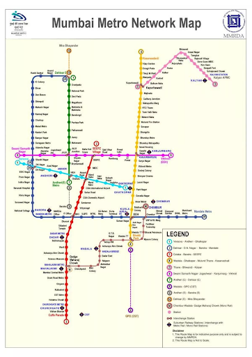
- The Mumbai Metro, designed as a 10-line urban Mass Rapid Transit System (MRTS), aims to serve the bustling city of Mumbai, the capital of Maharashtra.
- The Mumbai Metropolitan Region Development Authority (MMRDA) is responsible for overseeing the development of the metro system. In 2004, they introduced a master plan spanning 146.5 km with multiple lines.
- Various challenges, including policy dilemmas (EPC vs PPP, metro rail vs monorail) and environmental issues, have impeded progress. As a result, only one metro line connecting Versova, Andheri East, and Ghatkopar in the suburbs has been completed.
- In 2015, a new master plan covering 118 km received approval, gaining momentum with support from the government. This led to the development of two lines: Dahisar East – Andheri East (Red Line) and Dahisar East – D.N. Nagar (Yellow Line), along with the Cuffe Parade – BKC – Aarey Colony (Aqua Line).
- In June 2019, the Maha Mumbai Metro Operations Corporation (MMMOCL) was established as a nodal agency, tasked with operating and maintaining all Mumbai Metro services on MMRDA-owned lines.
- In September 2019, the MMRDA unveiled an expanded 337 km master plan for the Maha Mumbai Metro network, featuring 10 lines with a total of 17 sections.
- The Delhi Metro Rail Corporation has played a crucial role as the interim General Consultant, offering its services for the execution of most metro lines.
Overview of Mumbai Metro 2023

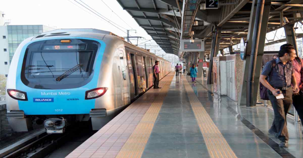
The Mumbai Metro, a vital component of the city’s transportation infrastructure, serves as a rapid transit system for the bustling metropolis of Mumbai, India. As of January 2023, it stands as the sixth longest operational metro network in the country, covering a substantial operational length of 46.4 km (28.8 mi). The primary objective of the metro system is to alleviate traffic congestion within the city and complement the heavily utilized Mumbai Suburban Railway network.
Read: List of Best Schools in Janakpuri, New Delhi 2024
The Mumbai Metro is envisioned to be completed in three phases over a 15-year span, with the overall completion expected by October 2026. Managed by Reliance Infrastructure and the Mumbai Metropolitan Region Development Authority (MMRDA), the metro system is characterized by its air-conditioned trains, comfortable seating, cleanliness, and wheelchair accessibility.
Travel Information:
- Fare Structure: The fare is distance-based, starting at a minimum of ₹10. Tickets can be purchased at metro stations or online.
- Operating Hours: The metro operates from 6:00 AM to 11:00 PM, although specific timings may vary by line and time of day.
List of Mumbai Metro Stations
| Metro Line | Name of Corridor | Colour | Stations | Length (KM) | Status |
| Mumbai Metro Line 1 | Versova – Andheri – Ghatkopar | Blue | Versova, DN Nagar, Azad Nagar, Chakala, MIDC, Andheri (East), Western Express Highway, Airport Road, Marol Naka, Jagruti Nagar, Ghatkopar | 11.4 | Fully Operational |
| Mumbai Metro Line 2A | Dahisar(E) – Andheri West | Yellow | Dahisar, Anand Nagar, Rushi Sankul, I.C. Colony, Eksar, Don Bosco, Shimpoli, Mahavir Nagar, Kamraj Nagar, Charkop, Malad, Kasturi Park, Bangur Nagar, Goregaon, Adarsh Nagar, Shastri Nagar, D.N. Nagar | 18.6 | Fully Operational |
| Mumbai Metro Line 2B | Andheri West – Mandala | Yellow | Andheri West, Bimal Bazaar, Aghadi Nagar, Bandra, National College, MMRDA, Income Tax Office, Siddharth Nagar, Lokmanya Tilak Terminus, Shatabdi Hospital, Prem Nagar, Naaz Hotel | 23.6 | Under Construction |
| Mumbai Metro Line 3 | Colaba – Bandra – SEEPZ | Aqua | Cuffe Parade, Vidhan Bhavan, Churchgate, Hutatma Chowk, CST, Kalbadevi, Girgaum, Grant Road, Mumbai Central, Mahalaxmi, Science Museum, Acharya Atre Chowk, Worli, Siddhi Vinayak, Dadar, Shitaladevi Temple, Dharavi, BKC, Vidyanagari, Santacruz, Chhatrapati Shivaji International Airport, Sahar Road, CSIA T2, Marol Naka, Seepz Village, Seepz | 33.5 | Under Construction |
| Mumbai Metro Line 4 | Wadala – Mulund – Thane – Kasarvadavali | Green | Wadala, Bhakti Park, Mysore Colony, Bharat Petroleum, Chembur, Diamond Garden, Shrishti Complex, Mankhurd, Mandala, Dharavi, Vadala Road, Siddhi Vinayak, Dadar, Khar, Vidya Nagari, Santacruz, CSIA International Airport, Sahar Road, CSIA Domestic Airport, Marol Naka, Seepz Village, Rani Rashmoni Chowk, Saki Naka, Asalpha, Jagruti Nagar, Sangharsh Nagar, Santosh Nagar, Aasha Nagar, Kanamwar Nagar, Vikhroli (E), Vikhroli (W), KanjurMarg, Bhandup, Nahur, Kalwa, Mumbra, Kalher, Purna, Anjur Phata, Dhamankar Naka, Bhiwandi, Kopar Khairane, Ghansoli, Airoli, Thane, Kasarvadavali | 32.32 | Under Construction |
| Mumbai Metro Line 4A | Kasarwadavali – Gaimukh | Green | Kasarwadavali, Manpada, Bhivandi Bypass, Gaimukh | 2.88 | Under Construction |
| Mumbai Metro Line 5 | Thane – Bhiwandi – Kalyan | Orange | Kapurbawdi, Balkum Naka, Kasheli, Kalher, Purna, Anjur Phata, Dhamankar Naka, Bhiwandi, Gopal Nagar, Temghar, Rajnouli Village, Govegaon MIDC, Kongaon, Durgadi Fort, Sahajanand Chowk, Kalyan railway station, Kalyan APMC | 24.9 | Under Construction |
| Mumbai Metro Line 6 | Swami Samarth Nagar – KanjurMarg – Vikhroli | Pink | Swami Samarth Nagar, Adarsh Nagar, Momin Nagar, JVLR, Shyam Nagar, Mahakali Caves, SEEPZ Village, Saki Vihar Road, Ram Baug, Powai Lake, IIT Powai, KanjurMarg (W), Vikhroli-Eastern Express Highway, Asmita Nagar, Vikhroli (E), Vikhroli (W), Kanjurmarg (E), Asara Depot, Bhandup West, Bhandup East, Nahur, Mulund West, Mulund East, Airoli, Thane, Kasarvadavali, Gaimukh | 14.7 | Under Construction |
| Mumbai Metro Line 7 | Dahisar (East) – Gundavali | Red | Dahisar (East), Ovaripada, WEH Metro, Goregaon, Aarey, Dindoshi, Pathanwadi, Pushpa Park, Bandongri, Mahindra & Mahindra, Magathane Depot, Devki Nagar, National Park | 16.5 | Fully Operational |
| Mumbai Metro Line 7A | Andheri (E) – CSI Airport | Red | Andheri (East), Sahar Road, CSMIA International Airport | 3.17 | Under Construction |
| Line-8 | CSIA – NMIA | Gold | CSIA International Airport, Sahar Road, CSMIA Domestic Airport, Kanjurmarg, Mhape, Nerul, Navi Mumbai International Airport (NMIA) | 35 | Proposed |
| Mumbai Metro Line 9 | Dahisar (E) – Mira Bhayander | Red | Dahisar (East), Anand Nagar, Rushi Sankul, I.C. Colony, Eksar, Don Bosco, Shimpoli, Mahavir Nagar, Kamraj Nagar, Charkop | 11.38 | Under Construction |
| Line-10 | Gaimukh – Shivaji Chowk (Mira Road) | Green | Gaimukh, Gaimukh Depot, Godhbunder Road, Shivaji Chowk (Mira Road) | 9.2 | Approved |
| Line-11 | Wadala – Chhatrapati Shivaji Maharaj Terminus | Green | Wadala, GTB Nagar, Currey Road, Mahalaxmi, Lower Parel, Chinchpokli, CST interchange with Line 1 & Line 3, Azad Maidan, Colaba, Navy Nagar, Cooperage Road, Mazagaon, Wadala Depot, G.D.A. Complex | 12.7 | Approved |
| Line-12 | Kalyan – Dombivali – Taloja | Orange | Kalyan, Patri Pool, APMC, Sonarpada, Pisarve, Taloja | 20.7 | Approved |
| Line-13 | Shivaji Chowk (Mira Bhayander) – Virar | Purple | Shivaji Chowk (Mira Bhayander), Miragaon, Pai Bagh, Majhiwada, Mayeenagar, Gaimukh, Bhayandar (East), Bhayandar (West), Bhayandar (East) | 23 | Proposed |
| Line-14 | Kanjurmarg – Badlapur | Magenta | Kanjurmarg, Nathnagar, Pisavli, Dombivli, Patharli, Malang Road, Mohone, Ambernath, Ulhasnagar, Ambernath (East), Ulhasnagar (West), Badlapur | 45 | Proposed |
Operational Lines
Line 1 (Blue Line): Versova – Ghatkopar
The Mumbai Metro Line 1, popularly known as the Blue Line, traces a transformative journey across the city, connecting the bustling western suburb of Versova to the vibrant eastern suburb of Ghatkopar. Spanning a distance of 11.4 kilometers, this metro line navigates through a diverse landscape, encompassing residential areas, commercial hubs, and key transit points. The route strategically cuts through the heart of Mumbai, offering commuters a swift and efficient mode of transportation.
Key Stations and Their Significance:
The success and utility of Line 1 lie in its strategic placement of key stations, each contributing significantly to the city’s connectivity and accessibility:
- Versova: Serving as the westernmost terminus, Versova is a major residential and commercial hub. The station acts as a gateway to the metro network for residents of the western suburbs.
- Andheri: As a bustling junction, Andheri is a vital transit point connecting the metro with the Western Railway and a network of local buses. It serves as a pivotal interchange for commuters traveling to and from the western suburbs.
- Ghatkopar: Located in the densely populated eastern suburb, Ghatkopar is a crucial station with access to the Central Railway. This bustling area is a key residential and commercial zone, and the metro station plays a pivotal role in enhancing connectivity for eastern commuters.
Impact on Local Commuting:
The introduction of Line 1 has left an indelible mark on local commuting in Mumbai, revolutionizing the daily lives of countless residents:
- Reduced Travel Time: Line 1 significantly reduces travel time between the western and eastern suburbs, providing a swift alternative to road-based transportation.
- Alleviation of Traffic Congestion: By offering a reliable and efficient metro service, Line 1 has played a pivotal role in easing road traffic congestion along its route, contributing to a more sustainable urban environment.
- Access to Essential Services: The strategically placed stations on Line 1 provide seamless access to educational institutions, healthcare facilities, and business centers, enhancing the overall quality of life for residents.
Monorail Line 1: Chembur – Wadala
Unique Features of the Monorail
Monorail Line 1 in Mumbai is a distinctive addition to the city’s public transportation, characterized by several unique features that set it apart:
- Elevated Structure: Unlike traditional metro lines, Monorail Line 1 operates on an elevated track. This elevated structure not only provides an unobstructed view of the cityscape but also minimizes the impact on existing ground-level infrastructure.
- Driverless Technology: Monorail Line 1 employs driverless technology, showcasing Mumbai’s commitment to embracing innovations in metro transportation. The automated system ensures precise control and efficient operations.
- Energy Efficiency: The monorail is designed with a focus on energy efficiency, making it an environmentally friendly mode of transport. The elevated track minimizes land usage, and the system’s energy-efficient features contribute to sustainable urban mobility.
Stations and Their Locations
Monorail Line 1 consists of 10 stations, strategically located between Chembur in the east and Wadala in the west. Each station serves as a crucial point of access, contributing to the connectivity of the areas they serve:
- Chembur: The easternmost station, Chembur, is a vibrant locality known for its residential and commercial establishments. The monorail station acts as a gateway for commuters from the eastern suburbs.
- Chunabhatti: This station serves the Chunabhatti locality, enhancing connectivity for residents and businesses in the vicinity.
- Mysore Colony: Located strategically, Mysore Colony station caters to the commuting needs of the surrounding residential areas.
- Tilak Nagar: Tilak Nagar station serves as a key transit point, connecting commuters to residential and commercial hubs in the Tilak Nagar neighborhood.
- Wadala: The westernmost station, Wadala, acts as a major interchange point with other metro lines, including Mumbai Metro Line 1. It provides seamless connectivity to different parts of the city.
- Wadala Depot: As a depot station, Wadala Depot is crucial for maintenance and operational activities related to the monorail system.
- Monorail Colony: This station caters to the needs of the local community in the vicinity of the Monorail Colony area.
- Anushakti Nagar: Anushakti Nagar station provides connectivity to the residential and institutional areas in the vicinity.
- Kurla: Kurla station, an important transit point, connects Monorail Line 1 with other major transportation networks in Mumbai.
- Phoenix Mills: This station serves the bustling commercial and entertainment district of Lower Parel, enhancing accessibility for commuters.
Brief Overview of Other Operational Lines (2, 3, 4, 4A, 5, 6, 7, 8)
Line 2 (Yellow Line): Dahisar – Bandra – Mandale
- Length: 42.23 km
- Stations: 32
- Status: Under Construction
Line 3 (Aqua Line): Colaba – BKC – SEEPZ
- Length: 33.5 km
- Stations: 28
- Status: Under Construction
Line 4 (Green Line): Wadala – Thane – Kasarvadavali
- Length: 32.32 km
- Stations: 24
- Status: Under Construction
Line 4A (Green Line): Kasarvadavali – Gaimukh
- Length: 13.5 km
- Stations: 11
- Status: Under Construction
Line 5 (Thane-Bhiwandi-Kalyan Metro-V corridor)
- Length: 24.9 km
- Stations: 17
- Status: Under Construction
Line 6 (Lokhandwala Complex-Jogeshwari-Kanjurmarg-Vikroli Link Road)
- Length: 33.5 km
- Stations: 31
- Status: Under Construction
Line 7 (Red Line): Andheri (East) – Chhatrapati Shivaji Maharaj Terminus (CST)
- Length: 33.4 km
- Stations: 27
- Status: Fully Operational
Line 8 (Gold Line): Chhatrapati Shivaji Maharaj International Airport (CSIA) – Navi Mumbai International Airport (NMIA)
- Length: 35 km
- Stations: 7
- Status: Proposed
Notable Stations and Their Roles in Connectivity:
- Dahisar East (Line 7): Major interchange station connecting Line 7.
- Aarey (Line 6): Key interchange station enhancing connectivity.
- Wadala (Line 1, Monorail Line 1): Critical interchange point linking multiple metro lines.
- Andheri East (Line 1, Western Railway): Strategic station connecting metro and Western Railway services.
Under Construction Lines (Line 2B, 7A, 9, 10, 11, 12)
Line 2B (Yellow Line): Andheri West – Mandale
- Current Status: Under Construction
- Key Developments: Track laying and station construction in progress; significant headway made in tunneling work.
- Expected Completion: Ongoing updates suggest a targeted completion within the next few years.
Line 7A (Red Line): Andheri (E) – CSI Airport
- Current Status: Under Construction
- Key Developments: Substantial progress in tunnel construction; station foundation work underway; alignment work near airport terminals.
- Expected Completion: On track for completion within the projected timeline.
Line 9 (Red Line): Dahisar (E) – Mira Bhayander
- Current Status: Under Construction
- Key Developments: Significant advancement in elevated corridor construction; station structures taking shape; progress aligns with the planned schedule.
- Expected Completion: Steady progress indicates completion within the scheduled timeframe.
Line 10 (Green Line): Gaimukh – Shivaji Chowk (Mira Road)
- Current Status: Approved; Pre-construction activities initiated.
- Key Developments: Initial groundwork, including land surveys and geotechnical studies; awaiting final clearances for full-scale construction.
- Expected Start Date: Construction set to commence after regulatory approvals.
Line 11 (Green Line): Wadala – Chhattrapati Shivaji Maharaj Terminus
- Current Status: Approved; Project planning underway.
- Key Developments: Preliminary design and feasibility studies in progress; stakeholder consultations ongoing.
- Expected Start Date: Construction to commence after finalization of detailed project plans.
Line 12 (Orange Line): Kalyan – Dombivali – Taloja
- Current Status: Approved; Detailed project planning initiated.
- Key Developments: Route alignment studies and environmental impact assessments underway; public consultations planned.
- Expected Start Date: Construction phase to begin post-comprehensive project approvals
Anticipated Impact on Commuting Patterns
- Enhanced Connectivity: The new lines aim to bridge gaps in connectivity, reducing travel time and providing additional transit options for commuters.
- Decongestion: Anticipated to alleviate traffic congestion in key areas, offering a faster and more efficient mode of transportation.
- Accessibility Improvements: Increased accessibility to commercial, residential, and educational hubs along the new corridors.
Challenges Faced During Construction
- Land Acquisition: Acquisition of land for station construction and alignment development has posed challenges, requiring careful negotiations and adherence to regulatory processes.
- Coordination with Other Projects: Alignment with existing infrastructure and coordination with other ongoing projects have necessitated meticulous planning to minimize disruptions.
- Utilities and Traffic Management: Managing existing utilities and mitigating traffic disruptions during construction are ongoing challenges requiring innovative solutions.
Proposed Lines (Line 13, 14, 15)
Vision for the Proposed Lines
Line 13 (Purple Line): Shivaji Chowk (Mira Bhayander) – Virar
- Vision: Extending connectivity to the outskirts, linking Mira Bhayander to Virar, creating a seamless transit corridor.
- Purpose: Catering to the growing population in the extended suburbs, fostering development in the region.
Line 14 (Magenta Line): Kanjurmarg – Badlapur
- Vision: Connecting the central suburbs to the far-eastern regions, promoting accessibility and regional development.
- Purpose: Facilitating smoother travel for residents in suburbs and boosting economic activities along the corridor.
Line 15: CST – Bandra
- Vision: Strengthening connectivity between the central and western parts of the city, reducing travel time between crucial business districts.
- Purpose: Enhancing accessibility for commuters and supporting economic activities along the proposed route.
Potential Benefits for Commuters
- Reduced Travel Time: The proposed lines aim to significantly reduce travel time between distant suburbs and vital business districts, enhancing overall commuter experience.
- Enhanced Connectivity: Improved connectivity between currently underserved areas and major transportation hubs, providing efficient transit options.
- Economic Development: Opening up new corridors can stimulate economic activities along the metro routes, attracting businesses and investments.
Community Impact Assessments
- Land Use and Development: Comprehensive assessments will be conducted to understand the impact on local land use and ensure sustainable urban development.
- Environmental Impact: Detailed studies will address potential environmental impacts, and measures will be taken to minimize the ecological footprint.
- Community Engagement: Initiatives will be launched to engage with local communities, gathering feedback, addressing concerns, and ensuring inclusive development.
- Social Equity: Evaluations will focus on ensuring that the proposed lines serve diverse communities, promoting social equity in access to transportation resources.
Note: The information presented is based on the current vision and conceptualization of the proposed lines and is subject to further planning and approvals.
Why Invest Near Mumbai Metro?
Are you considering real estate investment in Mumbai and seeking properties with excellent connectivity? The Mumbai Metro has significantly transformed the city’s landscape, and investing in localities with metro access is a strategic move. Here’s why you should consider investing in localities near the mumbai metro line:
- Connectivity: Proximity to metro stations ensures swift and hassle-free travel, attracting both residents and businesses.
- Appreciation: Properties near metro lines often experience higher appreciation due to increased demand and improved infrastructure.
- Rental Yield: With seamless connectivity, rental demand is high, providing a steady rental income for investors.
Investing in Real Estate: Top Localities Near Mumbai Metro with NoBroker
Looking for lucrative real estate opportunities near the Mumbai Metro? Explore the best localities with NoBroker for a seamless investment experience. NoBroker simplifies the real estate journey by connecting property owners directly with tenants and buyers, eliminating the need for intermediaries. With a vast database of properties and an easy-to-use platform, NoBroker ensures a smooth and cost-effective investment process. Investing in real estate near Mumbai Metro is a strategic decision for long-term gains. The localities mentioned, coupled with NoBroker’s efficient platform, offer a promising avenue for both seasoned and first-time investors. Seize the opportunity to invest wisely in the ever-evolving landscape of Mumbai’s real estate.
Faq’s
Mumbai Metro is a rapid transit system that serves the city of Mumbai, India. It is designed to provide a fast and efficient means of transportation, reducing traffic congestion and complementing the Mumbai Suburban Railway network.
As of January 2023, Mumbai Metro has three operational lines: Line 1 (Blue Line), Monorail Line 1, and Line 2A (Yellow Line).
Mumbai Metro offers air-conditioned trains, comfortable seating, clean and well-maintained stations, and wheelchair accessibility. The network is expanding to cover various parts of the city and its suburbs.
The fare in the Mumbai Metro is distance-based, with a minimum fare of ₹10. Passengers can purchase tickets at metro stations or online. The fare structure is designed to be convenient and affordable.
The metro timings vary by line and time of day, but trains generally run from 6:00 AM to 11:00 PM. For the latest timings, passengers can check the Mumbai Metro website or app.
The Mumbai Metro is operated by Reliance Infrastructure and the Mumbai Metropolitan Region Development Authority (MMRDA)


